YOSEMITE — One of the big rewards of visiting Yosemite is being able to savor incredible vistas from the rim overlooking the world-famous glacier carved Valley.
The less people the better.
But what if you’re not an elevation gain junkie?
One option is to get in the queue at the Badger Pass Ski Resort area and sit for 45 minutes or more to let rangers release you to continue the drive up to Glacier Point where a small army of visitors are swarming. The view is great but the crowds and the accompanying noise takes away from the experience.
So unless you want to rack up 3,000 plus feet in elevation gain taking the Yosemite Falls or Snow Creek Trail or reach the North Rim or use the Six Mile Trail (it’s longer than that) or the Tunnel View Trail to reach the South Rim, you could always head up Tioga Road do a more moderate cross country hike to reach the top of El Capitan, North Dome, or Yosemite Falls.
You can cut out a lot of the elevation gain and eliminate the crowd factor by hiking to Dewey Point along the less visited South Rim from the Tunnel View outlook on the way to Glacier Road
The elevation at the trailhead for the 7.8-mile round trip is 6,900 feet and the elevation at Dewey Point is 7,200 feet — 3,200 feet above the Valley floor.
You can also make it a 9.2-mile round trip and include Crocker Point or a 10.5-mile round-trip and visit Stanford Point along with Crocker Point and Dewey Point.
Non-hikers can still take in a view from the South Rim at Glacier Point.
Depending upon the traffic, you may have to wait in the queue at the Badger Ski Resort parking lot. It’s a good option if you want to shed the valley crowds and not have to deal with hiking a lot of elevation gain.
Or you can stop a way shy of Glacier Point and take the McGurk Meadow trail from Glacier Point Road. There is no parking lot, per se. but you can park along the road. About two miles into the hike you will reach the Pohono Trail that spans the South Rim. You turn left (west) to head to Dewey Point.
My preferred way of getting to Dewey Point is from the Tunnel View parking lot. This entails a little over nine miles round trip and takes in Inspiration Point, Stanford Point, and Crocker Point on the way to Dewey Point. If also involves a net elevation gain approaching 4,000 feet.
It’s on the strenuous side at first as you climb from the valley and becomes less so after that.
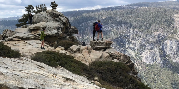
The great thing about the hike — whether from Tunnel View or Glacier Road — are the number of other hikers drop off to near nil the farther you get away from the trailhead. By the time you reach Dewey Point it's just a handful.
The stretch from Tunnel View to Dewey Point has more accessible points overlooking the valley than anywhere else.
I’ve hiked the trail three times — once on a 90-degree August day, on the cusp of autumn, and on an early spring day.
On the spring hike, I ran into snow in the higher elevation and had my view of the valley from Dewey Point obscured by clouds below..
Dewey Point is one of the few hiking destinations in Yosemite National Park where I linger — 45 minutes or more — once I reach it.
Normally I’ll summit Mt. Dana, reach Cloud’s Rest, or hike to El Capitan and soak in the views that are perhaps more stunning and am headed back down 20 minutes later due to concern about afternoon thunderstorms in the higher elevations, the return trip that may be a slog or the fact I can do without two dozen people milling around.
Dewey Point is tailor made for basking on the rocks while lifting your head occasionally to soak in the view.
There’s one other plus.
While the rock can be slippery, it is unlike El Capitan, North Dome, atop of Yosemite Falls or Clouds Rest that are angled in such a manner that if you lay on your stomach to peek over the edge to see a view looking 3,000 feet down your odds of making the nightly news as Yosemite’s latest victim is increased significantly.
I admit I err on the side of being chicken — fear is a good thing as I’m still standing after 69 years — but being able to look straight down the side of a massive slab of granite to the valley floor 3,200 feet down is an incredible feeling.
It’s a 2 hour and 45 minute drive to the Tunnel View parking lot trailhead from Manteca as the 115 miles includes speed zones in the national park and a nice long line at the Highway 120 entrance station to pay the $35 fee per vehicle that’s good for seven days.
To contact Dennis Wyatt, email dwyatt@mantecabulletin.com