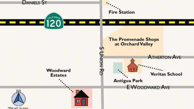
Woodward Estates and its proposed 77 single family home lots southwest of Union Road and Woodward Avenue had all the makings of a ho-hum affair when it advanced to the Manteca City Council.
Tentative subdivision maps by the time they reach the council level are virtually rubber stamped in instances where no one objects to plans during the environmental review process or at the Planning Commission.
But Manteca City Council members aren’t crazy about a “temporary” alley they fear will become a magnet for trash and vandals
And a couple that owns neighboring land that is still farmed dislikes it as well and went as far as to spend money out of their own pocket to hire an engineer to come up with a last minute alternative for streets and lot layout for the 16.73-acre project.
By the time the dust settled at Tuesday’s council meeting proponents for the Woodward Estates subdivision proposed on property owned by the Camara family faced the real possibility they could have the first tentative map rejected by a Manteca City Council in at least 22 years.
It all hinges on whether the council when they meet on Feb. 18 to take up the continued matter for a final decision determines whether the tentative map violates municipal policies relating to how growth should occur or fails to comply with the state map act.
Neighboring property owners Jack and Jane Lewis who farm on the southwest corner of Woodard and Union caused the routine approval process to come to a halt. But in all likelihood it won’t be their objections per se that could send the project back to the drawing board. And if that happens, engineers working for Woodward Estates proponents say it could cost their clients up to $300,000 and delay the project for months.
The Lewises do not like the street layout of Woodward Estates that stubs three east-west streets that dead-end at their property line. They contend it limits the future use of their property by preventing it from being used for commercial purposes. But as Community Development Director Frederic Clark pointed out, their land is zoned residential and as such the Woodward Estates project was processed by the proponent and the city based on that designation.
And while the general plan can be amended, it would be hard under current policies and zoning in place to find justification to reject the tentative map. The Lewises also want a 7-foot masonry wall instead of a wooden fence between their property and future homes saying that wooden fences weren’t enough to protect their agricultural operation.
However, the alternative maps for the Camara property suggested by the engineer the Lewises hired drew attention to four lots sandwiched between two of the east-west streets that border the property line. Those are the four lots that would remain vacant indefinitely until such time as the Lewis property developed. And since the city doesn’t want to have it’s garbage trucks backing up more than 150 feet down a street or not allow other vehicles room to turn around on what would be a “temporary “ dead-end street, the Planning Commission required a temporary “alley” paved to city street standards to go through the middle of the four lots.
The buyers of homes in Woodward Estates would be required to maintain the alley and required landscaping on the four lots in question until such time homes could be built on the lots.
Councilman Vince Hernandez, who suggested the postponed vote so council could further weigh the pros and cons, questioned whether the “temporary alley” meets city standards. As such, that stands as the only viable grounds for rejecting the tentative map.
The council can either approve or deny a tentative map. They can’t modify it.
The Lewises’ map had two of the streets connected through a U-shape street pattern leaving only one of the three streets stubbing at the property line with their farm. In doing so the proponents say they would lose five lots.
But as several council members pointed out, the “temporary alley” effectively renders four lots useless to build on indefinitely.
Manteca may say no to subdivision
Temporary alley impacts concern council members