Being bicycle and pedestrian friendly is not an afterthought at River Islands at Lathrop.
As work started on building the road to connect with a bridge across the San Joaquin River on the main entrance road that ultimately will connect with Louise Avenue that turns into River Islands Parkway west of Interstate 5, the architects of the integrated community of 11,000 homes realized the planned 18.5-mile bike path/pedestrian trail that will eventually encircle the development would be crossing what will ultimately be a heavily traveled four-lane road.
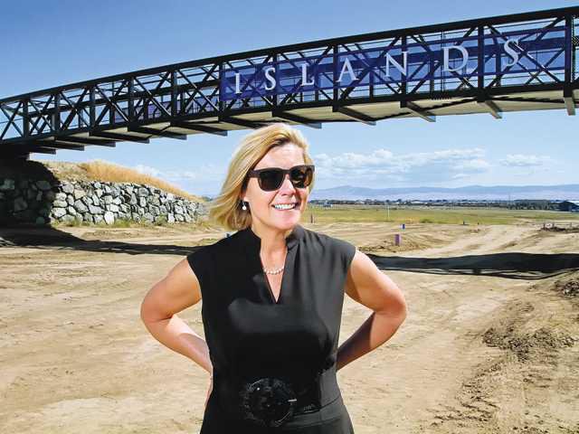
So before grading started on the road, River Islands tweaked their plans. Today the finishing touches are going on a bridge that will carry bicyclists, pedestrians and joggers across the four-lane road and serve as a welcoming monument of sorts to River Islands.
That means when all is said and done 20 or so years from now the 18.5-mile and 20-foot wide trail through the greenbelt park atop the super levees will end up requiring users to cross only one street to do a complete circle.
Meanwhile, River Islands is looking at keeping some existing older levees in place in future phases to use not just as redundant flood protection in addition to the 300-foot wide and 200-year flood protection rated super levees they are creating but to provide additional greenbelt parks.
Why this should be of interest to people who one day won’t live in River Islands is simple: The super levee greenbelt park will be available for anyone to use. When completed the greenbelt will be the longest uninterrupted bike trail in terms of street crossings in all of the Central Valley. The American River Parkway in Sacramento runs for 32 miles between Old Sacramento and Beal’s Point at Folsom Lake but segments between road crossings — although some are rather insignificant in terms of traffic — are much shorter than the 18.5 miles River Islands will have.
It will also be one-of-a-kind greenbelt in term of access to the San Joaquin River for the general public.
Bradshaw Crossing — the bridge that will carry traffic into River Islands that will pass beneath the greenbelt bridge — is the first new bridge crossing over the San Joaquin River within the county in at least 40 years. It will open later this years or early 2017 at the latest.
The bridge decks were put in place in 2012 by Cambay Group. Part of the reason was to take advantage of lower construction costs due to the recession but what really drove the decision was federal and state permits that had bene obtained were nearing an expiration date. The approaches were not put in place at the time to avoid people from accessing the bridge. It essentially created twin canopies over the river.
Grading for the approaches are in the process of being completed,
The bridge — 100 percent paid for by Cambay Group — wasn’t required to be built until the 800th home had been sold at River Islands at Lathrop.
.Eventually River Islands Parkway will extend westward across the balance of the planned community and into Tracy on its north side.
Ultimately anther freeway access point will be added along Interstate 205.
An effort is underway to get an Altamont Corridor Express commuter rail station along tracks that skirt the eastern end of River Islands where a business park is being developed. The intent is to make River Islands a true transit hub with jobs within walking distance of those arriving by rail and easily access to commuter trains to Bay Area jobs for the roughly 40,000 people expected to eventually live at River Islands.
Cambay Group plans to take advantage of the limited access to River Islands — eventually there will be only four access points to reach what is known on maps as Stewart Tract — to enhance the security and safety of residents.
To contact Dennis Wyatt, email dwyatt@mantecabulletin.com
Pedestrians come first at RI
Bridge crossing part of 18.5-mile greenbelt