
A controversial dryland levee needed to provide state-mandated 200-year flood protection for a large swath of southwest Manteca as well as part of Lathrop could go farther south than originally envisioned.
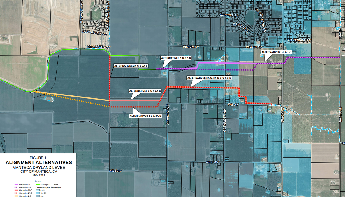
Engineers working with the San Joaquin Area Flood Control Agency (SJAFCA) have devised four additional alternatives for the cross-levee designed to hold back floodwaters for a 200-year flood when the San Joaquin and Stanislaus rivers fail south of Manteca.
Those river levees have failed 11 times since 1929 creating several 100-year floods including the 1997 event that brought flood waters lapping to the top of the existing dry levee that runs south of Woodward Avenue and ends west of Airport Way. Those flood waters that inundated 80 square miles between Manteca and Tracy came within dozens of yards of the Nile School campus.
The monikers 100-year and 200-year do not refer to the frequency of major floods but to the odds of how likely they could happen in any given year. They have become more of a misnomer to gauge the frequency of floods over the years as development that creates impervious surfaces such as rooftops, streets, parking lots, driveways, and sidewalks reduces the ability for rainfall to be absorbed into the ground to create a bigger runoff issue.
Originally the initial alternative advanced was extending the existing dry levee across Airport Way and run it between Peach and Fig avenues with it being closer to the south side of Peach Avenue. It would run as far as Tinnin Road in the east.
Engineers studied and then plotted four other alternative routes that in reality are variations of extending the dry levee and swinging the levee alignment farther south.
Research was able to dismiss assumptions a more southern route would be cost prohibitive. That’s because an analysis showed the actual height of the levee would be increased 1½ to 2 feet by a more southern alignment.
A more southern levee would extend roughly half a mile less to the east. It would end before reaching Union Road.
It would require a seepage berm footprint of 300-foot width along with a 20-foot wide access road on the north side of the levee. That seepage berm would end where hydraulic loading is less than 2 feet that occurs just west of Oleander Avenue. The 300-foot width is a maximum. Hydrology may allow the seepage berm to be as narrow as 100 feet in spots.
The levee is a raw issue for roughly 50 households primarily along Fig Avenue as well as parts of Peach Avenue and Oleander Avenue. That’s because of the potential for the levee to pass through the back of their properties.
Also adding to the friction is the properties south of the levee would not only be subject to flooding but property owners contend the levee in stopping the advancement of floodwater would end up subjecting their homes to even more water in terms of its height given land it could have spread into will be protected by the levee.
The most southern basic alignment would require a levee starting at 3.8 feet and then dropping to just over a foot at its eastern most point.
Most of the property south of the southernmost levee alignments is at an elevation where it is currently subject to somewhat greater than 3 feet of water during a 200-yead flood. As you head east the flood risk is between 1 and 3 feet.
An auxiliary issue for property owners is where the levee alignment would send the east-west Raymus Parkway alignment that would run from the new McKinley Avenue/Woodward Avenue intersection to as far east of at least Austin Road.
The southern alignment would set the stage for more residential development that the general plan update now being processed would allow by taking floodplain out of development.
Based on the land areas involved in the proposed Lumina neighborhood on the southwest corner of Airport Way and Woodward Avenue that is proposed for 827 homes, the area being taken out of the floodplain west of Airport Way and south of the existing dry levee could accommodate upwards of 1,700 more homes.
That would help make financing for the local share of the $180 million project to provide enhanced flood protection along the San Joaquin River for parts of Manteca, Lathrop, Stockton (Weston Ranch), and almost all of French Camp. All new construction within the 200-year floodplain in Manteca and Lathrop has an add-on fee for flood protection.
To contact Dennis Wyatt, email dwyatt@mantecabulletin.com