Bobby Troup wrote a song about it.
Nate King Cole recorded a version of that song.
And actors Martin Milner — later known as officer Pete Malloy in “Adam 12” and George Mahris — portrayed young men whose ventures crossing the United States on Rite 66 in a Chevrolet Corbett convertible were depicted in the early 1960sTV show known as “Route 66.”
The song is “Route 66”, a musical tribute to the pre-Interstate era federal highway route established in 1926 that ran 2,448 miles from Chicago to Santa Monica.
It was for two generations considered as the gateway route to California.
Troup’s lyrics included the lines “won’t you get hip to this timely tip, when you make that California trip, get your kicks on Route Sixty-Six.”
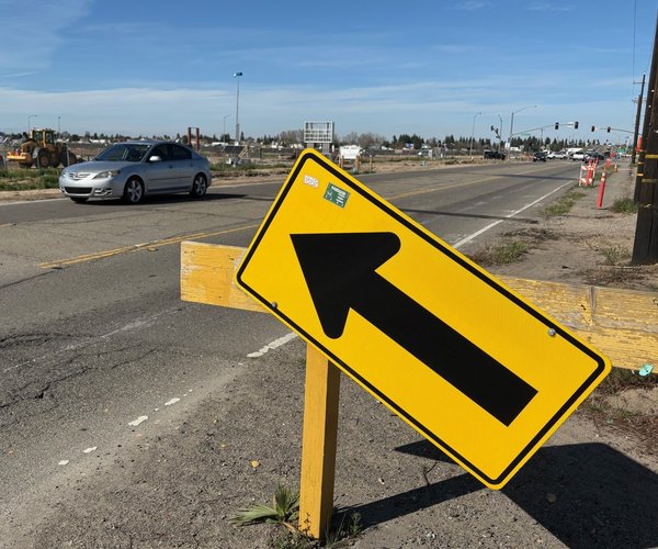
The biggest stretch of Route 66 — 178 miles of it – passed through San Bernadino County.
San Bernardino, when it comes to reasons for visiting California, likely wouldn’t make the top 10 list.
It is even given the Rodney Dangerfield treatment by those residing in the crowded coastal areas in Southern California.
That could be for several reasons.
Along with Riverside County, it is part of the Inland Empire of 4.74 million residents making it the 12th largest metro area in the United States beating No. 13 — San Francisco-Oakland-Fremont – by 100,000 or so people.
Even so, it is basically to Los Angeles-Orange County what the Northern San Joaquin Valley is to the Bay Area, a collection of suburbs/exburbs that serves not as the de facto affordable housing solution for the job rich coastal community but has emerged as its main distribution center hub.
Sound familiar?
The other reason is the 154 miles of the Interstate 40 freeway that starts in Barstow and takes you to the Nevada state line and the entertainment/gambling mecca of Las Vegas is all in San Bernardino County.
Most people can’t wait to pass through the county.
Admittedly, I had the same attitude my first time in San Bernardino County on a trip to Santa Fe, N.M.
The 144-mile segment between Barstow and Needles redefined boring. It made Interstate 5 between Lathrop and the Grapevine seem over populated by comparison with a rich tapestry of every changing scenery.
If you take historic Route 66, now known as County Road 66 through San Bernardino County, it isn’t much better even though the 178 miles is a notch up on Interstate 40 on the scenic intertest scale.
I am almost embarrassed to admit but the thing that stuck out the most in my mind during the first foray into San Bernardino County was how incredibly cool the air conditioning was in the AM/PM I stopped at in Needles.
That is why you should never judge a book by its cover or a county by what you see along a freeway built to move goods and people as fast as possible from point A to point B.
Speaking of freeway and the culture it spun, it would be remiss not to note the first McDonald’s restaurant popped up in the county’s namesake city in 1940.
San Bernardino County is home to 2.2 million people — making it the fifth most populated California county — and the state’s 18th largest city, San Bernardino, with 222,100 residents.
There are actually “two” San Bernardino County — one on the western side of the San Bernardino Mountains that were formed along the San Andreas Fault the highest peak reaching 11,503 feet — and that to the east.
Not to disrespect the western part of the county that is part of the Greater Los Angeles Area, but what is west of the San Bernardino Mountains is more on the scale of a Modesto on a small dose of steroids when it comes to visitor attractions.
Four of Southern California’s five ski resorts can be found in the San Bernardino Mountains.
It is where you will also find the popular four-season Big Bear Lake amid a rare sky island forest.
A sky island forest is a unique, isolated mountain range with cooler, wetter forests that rise dramatically from surrounding hot, dry lowlands such as deserts.
It is essentially a mountain range floating in a sea of desert.
You can drive just a few miles from the desert floor to a snowy forest.
In the same day — with less than 45 minutes in travel time — you can go from a desert ecosystem to an “island" of different habitats, from pine-oak woodlands to alpine firs, fostering high biodiversity and unique species.
If San Bernardino were
a state and not a county
One of San Bernardino’s biggest claims to fame is the fact it is the largest county in the United States.
If it were a state, its 20,105 square miles would come in at No. 42 behind West Virgina at 24,038 square miles and way ahead of Maryland at 12,406 square miles that is the actual 42nd largest state.
The county is also home to Fort Irwin, the largest Army base in the United States.
It serves as the U.S. Army's National Training Center.
As such it provides realistic, large-scale combat training in desert environments to develop ready units, adaptive leaders, and effective tactics for 21st-century warfare, focusing on large-scale combat operations against complex threats.
It is the northern end of the county just south of Death Valley.
San Bernardino is also home to the Marine Air Ground Task Force Training Command, Twentynine Palms.
It serves as the Marine Corps' premier combined-arms training center, preparing units for expeditionary warfare through realistic, large-scale live-fire exercises, combined arms training, and advanced tactical instruction for forces worldwide.
San Bernardino’s role in California agriculture has changed from the 19th century when navel oranges and livestock dominated.
Today, eggs ($192 million), livestock ($74.2 million), and milk/dairy products ($70 million) account for 76.3 percent of all production in the No .1-2-3 spots.
The No. 4 and No. 5 spots are non-edible ornamental trees, shrubs and roses at $25.6 million plus groundcover and bedding plants at $8 million.
The natural attraction
in the county? Desert
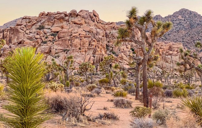
The biggest natural attractions in San Bernardino County are the deserts.
It includes slivers of two national parks — Death Valley in the northern part of the county and Joshua Tree in the southern part.
Joshua Tree is the only national park per se that includes part of two distinct deserts within its boundaries — Mojave, which is a high desert, and the Colorado, which is a low elevation desert.
They offer two distinct ecological systems.
Joshua Tree is popular for hiking, rock climbing, camping and stargazing.
It is also where you will find the largest concentration of Joshua trees.
Joshua trees aren't true trees in the botanical sense.
They're large succulents related to agaves and asparagus.
Joshua trees are called trees because they have tree-like forms — woody, branched, tall. They also fill tree-like niches in the desert.
They don't have growth rings like typical trees but are classified by form, making them "trees" in common language but not true botanical trees.
In the northern part of the county, you will find the Trona Pinnacles in the Searles Valley where movies such as “Star Wars” and a “Planet of the Apes” sequel was filmed.
San Bernardino County, the birthplace of actor Gene Hackman, has a long list of Hollywood credits including other major movies such as “The Fast & The Furious”, “Space Jam”, “Terminator 2”, and “The Aviator.”
Historical snippets
& various fact gems
The number of recognized ghost towns in the county outnumber the ranks of incorporated cities, 27 to 25.
There are also five Indian reservations.
The county was named in 1810 after Saint Bernardino of Siena.
He is the Roman Catholic patron saint of advertising, communications, compulsive gambling, respiratory problems, as well as any problems involving the chest area.
When Spaniards first walked on what is now eastern San Bernardino County, there was an estimated 1,500 Serrano Indians living there.
San Bernadino was made a county in 1853 three years after California became a state. It previously was part of Los Angeles County.
Two famous trails used by early day migrants and gold seekers — the Old Spanish Trail and the Mojave Trail — pass through the county.
The City of San Bernardino — the first settlement of consequence in the county — was formed by a contingent of the Church of Jesus Christ of Latter-day Saints that left Urah,
They bought 44,000 acres for $77,000 with $7,000 down from a rancher in 1851.
The Mormons proceeded to lay out a city on a mile grid pattern, similar to Salt Lake City.
The city was incorporated on April 1, 1854. At the time, it had 1,200 residents with 900 of them being Mormons.
The first three mayors were LDS apostles.
To contact Dennis Wyatt, email dwyatt@mantecabulletin.com