VISALIA — Largest tree by volume on earth.
More pristine Sierra wilderness that in Yosemite National Park.
Second deepest river gorge in the United States.
The tallest peak in the Lower 48 States.
Some 800 plus miles of hiking trails, the same as Yosemite National Park.
Less than half the visitors that crowd into Yosemite each year.
California’s longest cave at 17 miles.
Endless breathtaking views.
What place offers all that and more?
Sequoia National Park and Kings Canyon National Park.
The two national parks offer an unparalleled opportunity to savor the best of the Southern Sierra either as a casual visitor with short hikes or those more into higher elevation ventures.
Formed years apart, the two national parks are under the same management unit.
That means the $35, seven-day auto pass is good for both parks.
Sequoia gets about twice the visitors thanks in no small part to the presence of General Sherman, the world’s largest tree by volume.
It is also where you will find the second deepest river gorge canyon of some 7,700 feet where the 20-mile Kaweah River flows
That said, Kings Canyon has its share of giant sequoias plus other gems as well.
You could make it a day trip but at 187 miles from Manteca one way — as opposed to Yosemite at 90 miles — you’d be spending more driving to and from than exploring.
Visalia with 143,000 residents makes the idea base to visit both.
It is 34.9 miles to Sequoia and 52.4 miles to Kings Canyon from Visalia.
There is the added bonus of the Visalia to Sequoia National Park shuttle that is $15 for a round-trip. It drops you off to connect with the free in-park shuttle that takes visitors to a number of interest points including the General Sherman tree.
Both parks are open year around.
While winter isn’t the peak season, you can access a number of popular attractions including General Sherman that is a hike of under a mile but this time of year may require ice crampons due to the chances of snow being frozen over and slick.
And even if you’re not going to take a trip next weekend to visit the national parks, now is an ideal time to pencil out a date for a mod-spring to early fall trip especially if you want to reserve space at one of 14 campsites that can go quick.
There are 2 big attractions
in Sequoia National Park
The “star” of Sequoia National Park is General Sherman.
It’s somewhere between 2,200 and 2,700 years old.
It is also a sequoia, not a redwood.
There are some literally big differences.
Giant sequoias grow only on the western slopes of the Sierra in central California. They thrive at altitudes from 4,000 to 8,000 feet.
This restricted range means sequoias inhabit a unique environment with high elevation and well-drained soils. Significant precipitation, often snow, sustains them year-round.
Due to these specific conditions, sequoias grow in roughly 70 groves covering about 48,000 acres. They thrive in areas like Sequoia and Kings Canyon National Parks.
There are three groves in Yosemite National Park. The smallest grove of six trees is also the farthest north found deep in Placer County.
Redwoods grow along a narrow, humid strip of land along California’s northern coast, extending from Big Sur to the southwestern corner of Oregon.
They thrive in the mild, foggy climate where rainfall averages around 60 to 140 inches per year. The cool coastal air and frequent summer fog provide them with essential moisture, even during California’s dry season.
General Sherman is estimated to have a volume of 52,500 cubic feet or the equivalent of 630,000 board feet of lumber, enough to build 120 average-sized houses.
Experts note a single giant sequoia may contain more wood than is found on several acres of some of the finest virgin timberland in the Pacific Northwest. The trunk of General Sherman alone weighs nearly 1,400 tons. That is roughly equivalent to 15 adult blue whales or 10 diesel-electric train locomotives.
General Sherman rises 274.9 feet, has a circumference at the case of 102.6 feet, and its largest branch is 6.8 feet in diameter.
The first branch, by the way, does start until 131 feet above the ground.
The other “big” thing is Mt. Whitney.
At 14,505 feet, it is the tallest peak in the continental United States.
Hiking in from the closest trailhead from the west takes an average of six days.
Most people that hike it go in from the east from Whitney Portal at 8,360 feet out of Lone Pine where you pick up trail passes that must be secured via an annual lottery.
The 10.4-mile one-way trail is do-able in a one-day round trip staying in the Inyo Forest until you reach the summit in Sequoia National Park.
As such, I’ve been in Sequoia National Park five times, for stays of less than 30 minutes, at the summit.
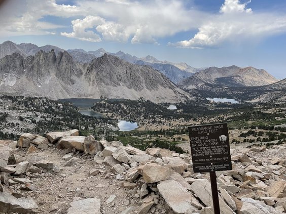
I’ve been inside Kings Canyon National Park for even shorter durations, hiking via the 11,972-foot Bishop Pass and 11,760-foot Kearsarge Pass. Both were from the east.
Kearsarge Pass offers arguably the best panoramic view of the Kings Canyon high country.
Home to Moro Rock
& 300 plus caves
The two national parks are where you will find more than 300 caves.
It includes Lilburn Cave, the longest in California at 17 miles.
Just one cave is open to the public via guided tours only. It’s the 3.4-mile-long Crystal Cave.
As you enter Sequoia National Park, Moro Rock looms thousands of feet above the highway. The large granite dome has a concrete and stone stairway of over 350 steps to the top.
The steps were tackled by President George W. Bush during a visit in 2001.
Even just a short distance from the parking area and above the forests’ canopy, the Great Western Divide's peaks become visible as you climb.
Farther up, views open up from the foothills and San Joaquin Valley to the west.
In winter, Moro Rock / Crescent Meadow Road closes with snow. Though ski trails lead to the parking area, the stairway is closed due to the danger of the icy or snowy steps.
Moro Rock is 245 feet above the meadow floor at an elevation of 6,725 feet.
Mineral King Valley saved
from a Mickey Mouse idea
The U.S. Forest Service in 1965 opened up the 7.5-mile long and mile wide subalpine glacial valley known as Mineral King Valley to development proposals.
Walt Disney Productions submitted a plan for a 1,100-room hotel and ski resort complete with 10 restaurants and an electronic bear ensemble that later became Bear Country Jamboree at Disneyland.
President Richard Nixon on Jan. 1, 1970 signed the National Environmental Projection Act.
That threw a roadblock just in time in the approval process for the project as it required federal agencies such as the Forest Service to assess the environmental impacts their proposed major actions ad involve the public in the decision-making process.
That gave the Sierra Club the ability to derail the project that was dropped several years later. President Jimmy Carter on Nov. 10, 1978 signed legislation that added Mineral Valley to Sequoia National Park.
The national park already surrounded Mineral King Valley, where silver was discovered in 1872 triggered a significant mining boom in the and around the valley floor at 7,500 feet.
Parks offer 800 plus
miles of hiking trails
There are numerous day hikes within the 800 plus miles of trails in Kings Canyon as well as Sequoia.
Some of the more popular ones are:
General Grant Tree Trail
One of the world's largest living trees. President Coolidge proclaimed it the Nation's Christmas tree in 1926. Visit the historic Gamlin Cabin and the Fallen Monarch along this 1/3-mile paved trail. Start at the General Grant Tree Parking area, 1 mile northwest of the Kings Canyon Visitor Center.
North Grove Loop
This lightly traveled, 1.5-mile trail provides an opportunity for a close look at the big trees. Enjoy a quiet walk past meadows and creeks, through mixed conifer and sequoia forest. The trailhead is at the Grant Tree parking area, 1 mile northwest of the visitor center.
Big Stump Loop Trail
Located just past the Big Stump Entrance to Kings Canyon National Park, walk through an old-growth giant sequoia grove that was logged in the late nineteenth century. This 2-mile loop trail passes along a meadow, a great place to see wildlife, and gives visitors an up-close look at large sequoia stumps.
Buena Vista Peak
The 2 mile round-trip hike up this granite peak begins just south of the Kings Canyon Overlook on the Generals Highway. Drive 6 miles southeast of Grant Grove Village, and park at the indicated area near the trailhead. From the top of Buena Vista Peak, a 360-degree view looks out over the majestic sequoias in Redwood Canyon, Buck Rock Fire Tower, and beyond to a splendid panorama of the high Sierra.
Big Baldy Ridge
This trail offers great views out and down into Redwood Canyon. A 2.2 mile to the summit at 8209 feet. From Grant Grove Village, go 8 miles south on Generals Highway to the trailhead. Park at the indicated area near the trailhead. Elevation gain is 600 feet; the roundtrip is 4.4 miles.
Monarch Lakes
Upper and Lower Monarch Lakes lie at the foot of Sawtooth Peak, at the end of a 4.2-mile (one-way) hike. This is one of the easier hikes in the Mineral King area, but since the trail follows a west-facing slope, it is best to get an early start. Beyond the lakes, the trail climbs 1200 feet in 1.3 miles) to Sawtooth Pass, a strenuous hike, but one that provides one of the grandest views in the southern Sierra.
Franklin Lakes
This trail provides many views of the rainbow-colored metamorphic rocks that attracted miners to this area in the 1870s, hoping to find silver. Although the 5.4-mile one-way hike can be done as a day trip, many backpackers make these lakes their first stop on their way over Franklin Pass to Rattlesnake Canyon, the Kern Canyon and Mt. Whitney.
Cedar Grove hikes
The Cedar Grove area of Kings Canyon National Park offers easy trails along the Kings River, and steeper trails that climb into wilderness. Maps and descriptions of the trails in this area are sold at visitor center book stores in Cedar Grove, Lodgepole, the Foothills (Ash Mountain),
Cedar Grove is typically open from May through early to mid-November. Opening and closing dates may change depending on weather and conditions. Some Cedar Grove facilities open later and close earlier, so be prepared if you visit there in spring or fall.
Trails accessible
year-round in parks
Trails in the foothills are accessible year-round.
Fall brings cooler temperatures for hiking in this diverse environment. In winter and spring, the foothills are clothed in a glorious array of wildflowers. Late March through late May is especially colorful.
As summer approaches the temperature rises, and so do the rivers
Marble Falls Trail
This trail climbs 3.9 miles through chaparral to a lovely cascade.
Middle Fork Trail
Leading through chaparral to high country, the first mile offers views of Moro Rock and Castle Rocks. Panther Creek Falls is 3 miles from the parking area.
Lady Bug Trail
Hike along the South Fork of the Kaweah in the upper foothills (moderately steep). The trail ends 3 miles near one of the lowest-elevation sequoia groves. The trail begins at South Fork Campground. From the campground, cross the river via a footbridge to find the trailhead.
Garfield Grove Trail
This trail is a relatively steep 5-mile one-way climb to the Garfield Sequoia Grove.
From. South Fork Campground start on the south side of the river in the campground.
To contact Dennis Wyatt, email dwyatt@mantecabulletin.com