The level of the San Joaquin River at the Airport Way bridge has risen 3 feet in the last three days as dam operators scramble to make room in Don Pedro Reservoir for a surge in snowmelt.
Overall, the watersheds that flow into the Northern San Joaquin Valley and ultimately pass Airport Way as water moves to the Delta could see 160 inches of snow, the accompanying foothills up to 11 inches of rain, and the valley floor up to 5 inches of rain between now and Tuesday from two back-to-back systems.
The stepped up releases are a bid to reduce the potential for downriver flooding where many levees are already saturated after weeks of rain.
One of the critical spots is where the San Joaquin River meets the Stanislaus River after the Tuolumne and the Merced rivers flow into it.
That confluence is 10 miles south of Manteca near the Airport Way bridge.
It is where a series of 11 levee breaks in 1997 flooded 70 square miles between Manteca and Tracy.
Dion Pedro’s 2.030,000 acre-foot reservoir on the Tuolumne River is at 100 percent of average capacity and 77 percent of overall capacity with 1,560,300 acre feet of water
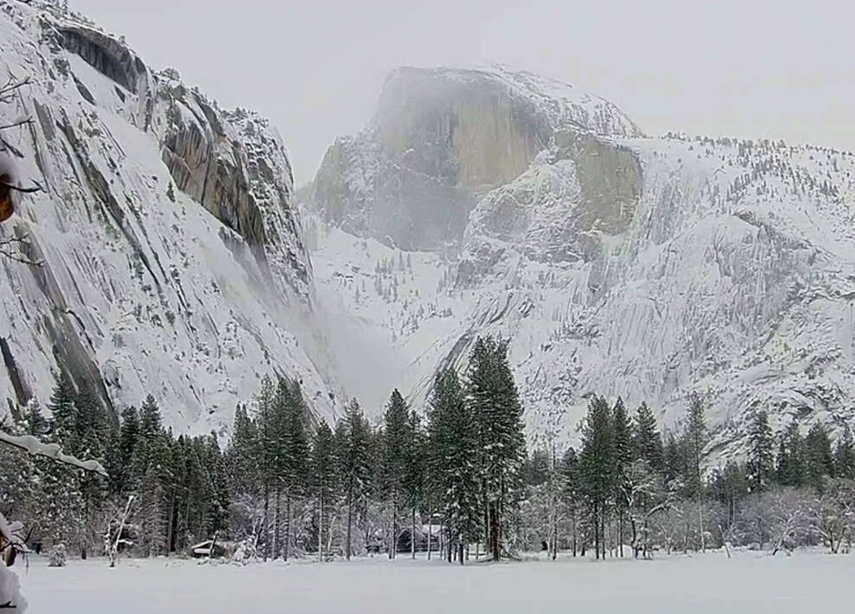
Some 100 inches of snow from the current system that is slamming the region through Sunday is expected to fall on the upper reaches of the Tuolumne River watershed through Sunday.
The biggest concern, however, is the expectation as much as 7.5 inches of rain will fall through Sunday in the foothills.
Those foothills, covered with several feet of snow along with snow in the lower mountain regions have the potential for a massive snowmelt that could overwhelm Don Pedro.
As such, Don Pedro as of Thursday night, was releasing 6,799 cubic feet of water a second — or the equivalent of 6,799 basketballs filled with water passing a specific point in a second. The inflow to Don Pedro is at 5,197 cubic feet per second.
Meanwhile, New Melones is only releasing 48 cubic feet per second compared to an inflow of 2,195 cubic feet per second on the Stanislaus River watershed.
New Melones is at 78 percent of average capacity with 1,136,000 acre feet in the 2.4 million acre foot reservoir. It is at 47 percent of overall capacity.
In 1997, the two reservoirs were operated not for flooding but to maximum water storage when warm weather hit in late December and January with a significantly above average December snowpack that is minuscule compared to what is now accumulating.
By the time they switched to flood mode both dams came perilously close to being breached hence increased river flows that pounded levees south of Manteca and Lathrop.
Manteca, Ripon and Lathrop are expected to get up to 3 inches of rain through Sunday
The National Weather Service that on Wednesday had predicted up to 100 inches of snow on Tioga Pass (Highway 120) and 80 inches on Ebbetts Pass (Highway 4) and Sonora Pass (Highway 108) upgraded its forecast to say all three passes now could accumulate 100 inches from the current storm.
A second warm system arrives Monday. It is expected to drop another 60 inches of snow on the Sierra crest and as much as 2 inches of rain in Manteca, Ripon, and Lathrop.
Overall, the watersheds that flow into the Northern San Joaquin Valley could see 160 inches of snow.
The San Joaquin River level of 20.48 feet at 10 p.m. Thursday was 8½ feet from the first flood stage of 29 that is considered minor. Moderate flood stage is 32 feet. Major flood stage is 37.3 feet.
The issue with levees in the South County is not being breached per se but boils happening that undermine the levee from below creating failures.
The San Joaquín River at Airport Way crested at 25.57 feet on Jan. 18 at the series of atmospheric rivers in January.
As a wet winter continues to fill California reservoirs, water managers set their sights on flood prevention by releasing water from stockpiles to make room for approaching storms and melting snow from the Sierra.
With the warm atmospheric rivers expected to cause local flooding, the looming question is whether warm rains will melt much of the near-record snowpack and bloat the state’s rivers over coming weeks.
Reservoir operators typically aim to keep water levels high ahead of summer months, but the race to make room for additional water underscores how weather extremes are making management of the state’s water infrastructure increasingly challenging.
“Water management in California is complicated and it’s been made even more complex with these challenging climate conditions, where we see swings between very dry and very wet then back to dry and now we’re back to wet,” said Ryan Endean, a spokesperson at the Department of Water Resources in a news briefing Thursday.
Bureau of Reclamation staff said over the next few days they are releasing water in increasing intervals for two days from Folsom Dam into the American River for flood protection in the Sacramento region, as well as from Friant and Shasta dams.
To contact Dennis Wyatt email dwyatt@mantecabulletin.com