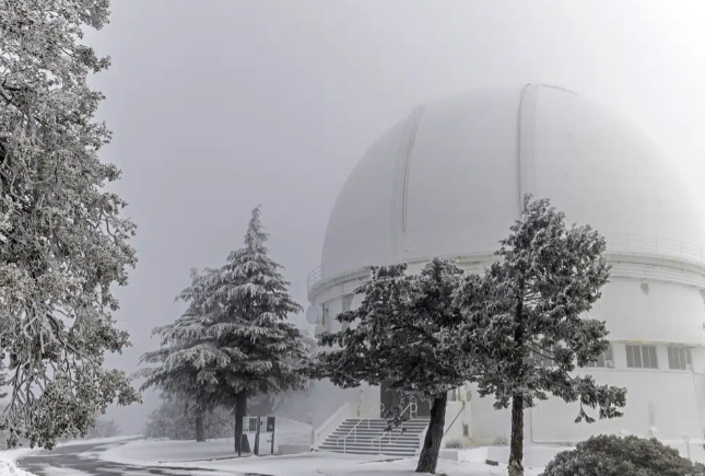
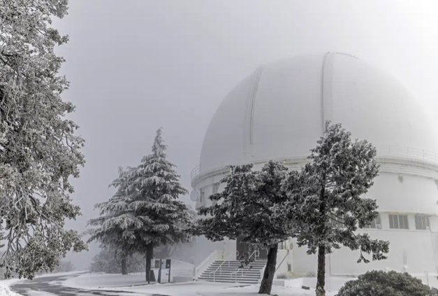
Significant low elevation snow is in the forecast for today and into Saturday.
The National Weather Service anticipates the snow level could drop as far as 500 feet in the Sierra and the Diablo Range today with the potential for snow in the Northern Sacramento Valley near Redding and Chico.
It will be the initial 1-2 punch of two storms moving through Northern California between now and Wednesday.
If snow does go down to 500 feet, it could be the heaviest snow coating on Mt. Diablo in at least two decades.
Mt. Diablo at 3,849 feet towers over the western edge of the Delta northwest of Manteca and Lathrop.
In recent years there has been dustings of snow at 1,000 feet or so south and north of the 1,009-foot Altamont Pass on Interstate 580 heading into the Bay Area.
If the forecast is correct, snow will be much lower and have heavier accumulations possible today and into Saturday.
Upwards of four feet of snow could fall on Sonora Pass (Highway 108) and Tioga Pass (Highway 120) today and Saturday.
Winds in San Joaquín County were anticipated overnight and today to have the potential to reach 45 to 50 mph.
Upwards of an inch of rain was predicted to fall overnight through this afternoon in the Manteca area.
Northern San Joaquín Valley temperatures are expected to be cold Saturday. Rain and snow is forecast in the foothills and snow in the higher elevations.
Valley rain will return in the PM on Sunday and occur off and on through Wednesday.
Sunday and Wednesday is expected to see little to no rain with Monday and Tuesday receiving light rain.
Overall, as much as an additional inch of rain could fall in the valley between Sunday and Wednesday.
The second storm, arriving Sunday in the PM and lasting through Wednesday will see the snow level down to 2,000 feet.
The next storm will dump even more snow in the Sierra. It could add as much as 4 more feet on Tioga Pass and another 5 feet on Sonora Pass.
When all is said and done, between now and Wednesday as much as 10 feet of snow may fall on the Sierra crest.
The storm slamming the state today is part of a coast-to-coast system that paralyzed roads and blacked out nearly 1 million homes and businesses.
It has triggered warnings throughout California of possible floods and blizzards.
The National Weather Service warned of a "cold and dangerous winter storm" through Saturday. As much as 5 feet (1.5 meters) of snow could fall in some mountains near Los Angeles, which could create whiteout conditions as winds gust to 75 mph and an increased risk of avalanches, forecasters said.
The weather service issued rare blizzard warnings for Southern California mountain areas and urged drivers to avoid dangerous roads.
Portions of Interstate 80 in California and Wyoming were closed Friday because of impassable conditions. That included about a 70-mile stretch over the top of the Sierra linking California and Nevada.
The weather front was creating vastly different conditions in different parts of the country.
"Southerly flow ahead of the front is creating mild and warm conditions for much of the Southeast and Mid-Atlantic while northwesterly winds behind the front are pushing cold arctic air into the Plains and Upper Midwest," the weather service said.
Usually balmy California saw unusual winter weather.
Karen Krenis was driving to a pottery studio in Santa Cruz in the San Francisco Bay area on Thursday when she stopped in her tracks after seeing snow on the beach. She got out of her car and went to take photos. By the time she left, about 50 other people were there. Adults were snapping photos, and children were making snowballs.
"I have lived in California for 30 years, and I've never seen anything like it," Krenis said.
In Southern California, the storm began moving Thursday with widespread rain and some snow flurries. There was even a dusting of snow or graupnel — a sort of soft hail — Thursday morning in the hills near the Hollywood sign, although it quickly vanished.
Flood watches and warnings were in effect through Saturday afternoon for some coastal regions and valleys, and the potential for heavy rainfall causing flooding and debris flow in some areas burned by wildfires in recent years.
Evacuation warnings also were issued in Ventura County for four areas that were considered unstable after being hit hard by storms last month.
The weather service said temperatures could drop far below normal in the region. That posed a special risk to thousands of homeless people, with shelter space limited and freezing temperatures expected in some areas.
Terry Stephens, who lives in a trailer with her son and his girlfriend in Palmdale, was temporarily placed in a hotel room in the Antelope Valley city northeast of Los Angeles after shivering through the night on Wednesday.
"It was frigid; your bones ache and you can't get warm," she told the Los Angeles Times. "I had three blankets on me last night and I was still freezing. Nothing helped."