
The decision to go with a secondary levee to protect southwest Manteca from a 200-year flood instead of bulking up existing levees along the San Joaquin and Stanislaus rivers not only saves money but effectively limits growth.
City Manager Karen McLaughlin said expanding the existing river levees was vetted early on in the process of responding to the state flood protection mandate.
But it was dismissed as too costly. Extending and increasing the height of an existing secondary levee (also referred to as a cross or dry levee) was seen as a more cost effective option.
In going with the dry levee option, however, the city essentially decided that wherever the cross levee is placed will serve as a de facto urban growth limit.
That’s because anything south of the dry levee will only have 100-year flood protection. Under new state guidelines no urbanization can occur in a 100-year flood zone any longer after July 1 of this year unless there is a mechanism put in place complete with a funding plan for 200-year flood protection by 2022.
The city is in the process of working with a consultant and impacted property owners to determine the exact alignment of that dry levee. It currently exits in part south of Woodward Avenue and west of Airport Way. With the new 200-year floodplain designation, it will have to be extended to a point somewhere just to the west of Union Road.
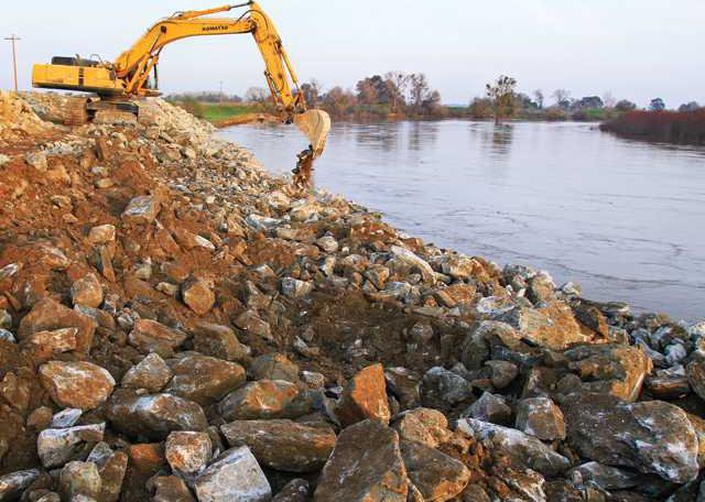
The existing dry levee had been protected with plastic sheeting and sandbags during the 1997 flood when water reached it after nine breaches in levees along the San Joaquin and Stanislaus rivers south of Manteca. The area northeast of the confluence of the two rivers has flooded nine times since 1927.
It was touch and go for several days during the 1997 flood as crews patrolled the dry levee 24/7 looking for potential failures.
The only way to obtain 200-year flood protection for the area southwest of Manteca short of somehow dredging or deepening the river channels is to increase the height and width of existing levees.
Super levees are
extremely problematic
Dredging is considered a next to impossible option given how the state has fiercely — and successfully — fought such work from taking place elsewhere as being disruptive to the environment.
But even converting the existing river levees into ones that would provide 200-year flood protection is next to impossible.
Across the San Joaquin River Cambay Group worked for five years to try and secure a battery of federal and state permits to strengthen the levees but only managed to get a handful of those that were needed. And as they were working on the other permits that they had to have before they could do any work, the ones they already secured were getting ready to expire.
Cambay Group engineers thought out of the box and came up with the solution of 300-foot wide super levees that are now in place.
It was accomplished without permits or any need of state or federal approval by building a parallel levee and then filling in the gap between the new levee and the existing levee. Under state and federal rules that was doable while simply expanding and strengthening the existing levee couldn’t be done without a battery of permits.
The super levee cost River Islands $70 million a decade ago for the required earth work. No dirt was imported to Stewart Tract while lakes were created for the 10,500-home planned community to deal with water exposed from a high water table after the earth movement.
Repeating the process on the east side of the river would be extremely problematic. If soil had to be imported it would send the cost sky high. But in order to use nearby dirt it would have to uproot a number of square miles of farmland.
If the levees were somehow converted into super levees to provide 200-year flood protection there would be nothing to stop future urbanization all the way to the pocket area at the confluence of the two rivers.
No project means
2,000 plus Manteca
homeowners would
have major problems, costs
Not proceeding with any levee improvements would not only halt new development not vested with maps and other regulatory approvals prior to July 1, but under state law the lack of 200-year flood protection would mean no existing structure could be expanded whether it is a house, a distribution center or an outbuilding such as a shed.
That would impact more than 2,000 homes in southwest Manteca south of Woodward Avenue and west of Union Road including new homes now being built as well as housing and businesses along the Airport Way corridor up until about Roth Road.
Such a ban would also apply to all of Lathrop and Weston Ranch.
That is in addition to the costly requirement of flood insurance that can run $2,200 a year for a typical existing home. While existing homeowners would not be mandated to carry flood insurance, it would be required of any new mortgages making it extremely difficult to sell existing homes.
The overall cost of levee upgrades is expected to reach $168 million with Manteca picking up a third of the tab and Lathrop the rest based on area impacted. Undeveloped land where growth will take place will be assessed with fees for the work.
On Tuesday, the Manteca City Council will consider approving a contract with Professional Strategic Financial Planning Services for urban flood protection financing. The council meets at 7 p.m. at the Civic Center, 1001 W. Center St.
WET VS. DRY
Dry levee: Less cost, less growth

