It was the defining moment of the January 1997 floods.
A KCRA-TV news crew was standing in the backyard of a Weston Ranch home that was on a street where every family was busy loading up rental vans with whatever possessions they could jam inside.
The camera was focused on a young couple with anxiety on their faces.
The husband started to speak as the camera panned from the back side of his home to his back fence.
“If we had known it could flood here we never would have bought the home.”
Just as he finished his sentence the camera stopped on the nearly 20-foot high backside of the French Camp Slough levee that was right behind his house.
One had to wonder what he thought the almost 20-foot-high mound of dirt behind his house was for anyway.
But in the homeowner’s defense, he is like other Californians living in a dreamland with no reality of where their water comes from or how it is kept from destroying half the state.
If anyone did, who would buy in Weston Ranch — the lowest point in the county outside of the Delta proper — without at least making it a top priority to make sure the levees protecting their home were well maintained instead of just assuming they are.
There is almost a universal denial that California is what it is today because we have managed to harness, store, and direct the run-off from the Sierra, Cascades, Trinity Alps, and Siskiyous.
And while it may not flood this year, the next water bursting through levees will one day again flood parts of the South County just as it has 11 times since 1929.
Development throughout the San Joaquin Valley watershed has shot holes in the myth of “100-year flood events” as such catastrophes are looking more and more like every 10-year affairs.
How flood events are measured involves jargon that easily gives the wrong impression unless one is versed in hydrology.
The terms such as 100-year floods and 200-year floods do not refer to frequency over time. Instead, it references the odds of a specific scale of flooding event happening in any given year.
A 100-year flood — of which the Mossdale Tract water basin where Lathrop, parts of Manteca and the Weston Ranch area of Stockton is located, has had at least three flooding events in that scale during the past century — has a 1 in a 100 chance of happening in any given year.
A 200-year event — protection against that the San Joaquin Area Flood Control Agency (SJAFCA) has been working methodically since 2017 to get into place — has a 1 in 200 chance of happening in any given year.
The measuring standards were established in the 19th century.
It was long before there was adequate “recorded hydrology history” or the benefit of dendrochronology — the study of tree rings — assisted by carbon dating.
The accusations local officials have been asleep at the wheel as some contend who are irked about the prospect of having to pay for a flood control assessment or else risk losing everything they own is laughable.
From day one, when development of the Central Valey started during the Gold Rush by those wishing to prosper by selling beef and other food to miners — flood control has been pursued by local leaders in much of what is today San Joaquin County.
Given the bulk of the Delta is within the boundaries of San Joaquin County, you could argue where we live is the most flood-prone region in California.
Without levees and other flood control measures that started popping up in the 1850s much of present-day Stockton, all of Lathrop, and parts of Manteca would be a muddy and wet mess during the rainy season and during the spring snow runoff.
Hurricane Katrina that caused levees protecting New Orleans to fail in 2005 was what set in motion the California mandate signed into law in 2007 requiring minimum protection in urbanized areas throughout the state to defend against a 200-year event.
That said, Stockton — and the rest of the Central Valley — set the standard for urbanized flooding that a 200-year event and worse can unleash way back in 1861-62.
It consisted of rain virtually unbated for 43 days starting on Christmas Eve of 1861. It also led to immense snowfall in the Sierra that was capped with an unseasonably warm deluge of rain in the high Sierra.
That triggered a massive snowmelt runoff.
Almost all of the Great Central Valley stretching 450 miles from Redding to in the north to Bakersfield in the south — was underwater.
Some areas it was just a few feet.
But in settlements and cities like Stockton and Sacramento along rivers in the center of the 40 to 60 mile wide valley, floodwater exceeded 10 feet in many areas urbanized and otherwise.
The state’s entire population at the time was 379,994. San Josquin County today has twice that amount of residents.
It is why the 1861 damages that translate into $3.2 billion in today’s dollars were miniscule compared to what would happen if a similar flood happened today.
It is clear based on historic hydrology we are due for a repeat flood on the scale of the 1861-62 event.
There are a lot more dams and levees in place, but keep in mind most levees were built in the 1860s after Californians got the message loud and clear what Mother Nature was capable of doing.
And while most levees had been patched or re-enforced over the years, they weren’t really overhauled such as they were for 100-year flood protection in parts of the Stockton area back in the 1990s when SCAFCA was formed by Stockton and San Joaquin County.
But that effort in the 1990s protected against 100-year events, not 200-year events.
Modeling by the state Department of Water Resources show that weather patterns are shifting once again to more rain in the valley and less snow in the Sierra.
They also show warmer rains are likely to hit what snowpack there is earlier in the rainy season.
It is why models show the runoff volume in the San Joaquin River basin will increase nearly threefold by 2070 putting immense strain on the ability of dams and levees to avert disaster
Manteca and Lathrop joined SJAFCA in 2017 when they realized the immense price tag and complexity of 200-year flood protection needed a regional approach.
If you’re one of the 22,000 property owners that got a SJAFCA ballot in the mail regarding a 30-year assessment leverage a $473 million flood protection project and you have the urge to vote no, check out what you’re gambling with before you mark your ballot.
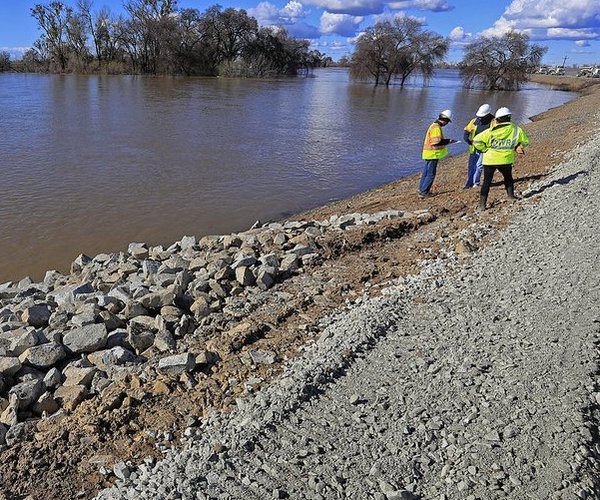
Go stand atop the mound of dirt reenforced by rock.
Look in the general direction of your home.
Imagine the levee failing or being breached
If you’re like the vast majority of those receiving the ballots, your home would end up being flooded with 1 inch to 4 feet of water. Those closer to levees could receive up of 8 feet of water.
It’s your choice.
Spend a relatively few dollars over 30 years for preventative measures or risk losing it all.
This column is the opinion of editor, Dennis Wyatt, and does not necessarily represent the opinions of The Bulletin or 209 Multimedia. He can be reached at dwyatt@mantecabulletin.com