
Were you among the 22,000 property owners in parts of Manteca, Lathrop, and Stockton to get a ballot in the mail regarding an assessment for enhanced flood protection?
Depending upon your home’s exposure and variables, a yes vote will cost you between $8 and $80 annually for the next 30 years.
It will buy upgraded flood protection.
And if you have a federally guaranteed mortgage, you will avoid a likely federal mandate for flood insurance that will cost you in the neighborhood of $1,700 a year.
If your mortgage isn’t guaranteed by Uncle Sam, when you go to sell your house you will need to legally disclose it is in a dangerous floodplain which will do a number on how much money you can get for your home.
If you want to better understand why you should vote yes, take a drive.
Turn off Airport Way and onto Atherton Drive and head eastward into the giant development jigsaw puzzle now seemingly trying to be pieced together all at once in southwest Manteca.
You will reach the new intersection with McKinley Avenue.
Turn right and your progress will soon be impeded on the four-lane wide expanse of asphalt by barricades that direct you onto Brozan Road and prevent you from going farther north to travel under the 120 Bypass.
In the coming weeks, the McKinley Avenue interchange will open and those barricades will be removed.
And given it will relieve a lot of congestion on Airport Way that a lot of people have to deal with — especially those with only one basic way and out of their neighborhoods in the pocket area of southwest Manteca — the removal of the barricades will make a lot of people happy.
Go back 27 years.
McKinley Avenue was also barricaded in January of 1997.
And when barricades were removed then, a lot of people were happy as well.
Today’s barricades are sections of concrete K-rail.
Back then, the barricade was 20 truckloads of dirt covered with thick black plastic that was weighed down with sandbag directly below the eastbound bridge deck.
It plugged the gap to about a height of 8 feet.
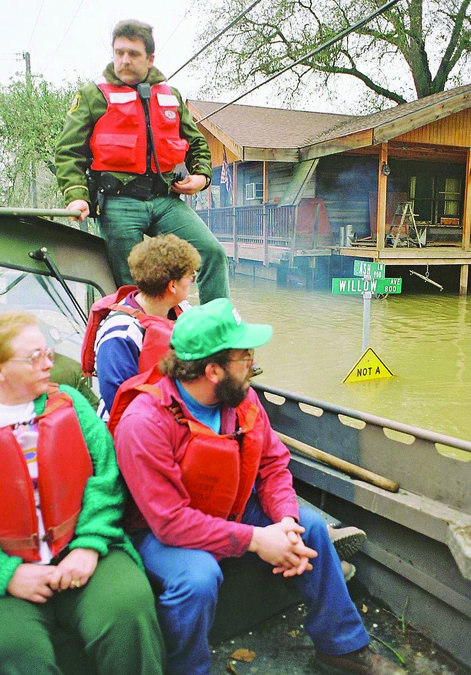
Less than a mile away to the south, there were patrols around the clock walking along a “dry levee” that had been sheeted with black plastic kept in place by sand bags.
You could hear the sound of water lapping against the south side of the dry levee.
McKinley Avenue passing beneath the elevated 120 Bypass had been plugged.
The 120 Bypass has been turned into a de facto back up emergency levee.
If levee breaks on the San Joaquin River had continued and the dry levee been breached or failed, three to four feet of water would have been flowing northward via the McKinley Avenue underpass.
It would have gone as far to the east as the neighborhoods around Sierra High.
Floodwaters would have traveled northward along the Airport Way.
There was nothing west of Airport Way in Manteca back in 1997 except for the city’s wastewater treatment plant, the school district office, and a handful of homes.
Today you’ll find Costco, Big League Dreams, Stadium Retail Center, Big League Dreams, tract homes under construction and more.
In Lathrop, Stewart Tract — now known as River Islands, was underwater.
In Old Lathrop — the area east of Interstate 5 north — people were loading cars and trucks with essential belongings.
The Interstate 5 underpass on Louise Avenue had been plugged just like McKinley.
A skip loaded and piles of dirt were in place to do the same thing at the Lathrop Road underpass of I-5.
Further north in Weston Ranch, which is a lower elevation than Lathrop, driveways on street after street had rented vans brought in from across Northern California and Nevada loaded and ready to leave.
The California Office of Emergency Services had issued a warning.
Should the levees at the southern end of Mossdale Tract fail, floodwaters would reach Weston Ranch in seven hours.
Boils, often a precursor, to levee failures, were popping up left and right where the San Joaquin River makes a sharp bend near the Mossdale Crossing before splitting into the Old River and Main River channels for start it’s meandering journey through the Delta.
Back in 1997, there was no development in Lathrop west of Interstate 5.
Ditto for Manteca southwest of the 120 Bypass and Airport Way interchanges.
Stewart Tract proper had two houses as opposed to the 15,001 homes Cambay Group is building.
Every 20 to 30 years Stewart Tract would flood.
Not anymore.
That’s because Cambay Group spent upwards of $100 million rearranging dirt in Stewart Tract creating super levees that are 300 feet wide.
They withstand a 200-year flood.
A quick explanation is needed for flooding lingo.
Terms like 100-year and 200-year floods are not a reference to frequency.
Instead, the numbers are based on the odds of a specific sized flooding ever occurring in any given years.
To be clear, the system was based on old modeling and limited modern era data stretching back to the 1850s.
The flood rating system was developed before the science of dendrochronology — the study of tree rings to determine past perception patterns — was effectively enhanced using carbon dating.
And it was before more and more impermeable surfaces were in place in the San Joaquin River Basin such as roof tops, sidewalks, streets, and parking lots.
All of that creates more runoff.
The latest Department of Water Resources modeling shows the flow of the San Joaquin River will triple by 2070.
This is based more on natural climate change, cyclical weather pattens going back hundreds if not thousands of years in what is now the western United States, than it is on climate change that can be attributed to man’s activities.
Are the models absolutely correct?
No models ever are.
Do they generally catch trends?
Yes.
And the trends they all agree on using data is that we are returning to a period where there will be less snow falling in the mountains in a typical year.
At the same time there will be a significant uptick in rain in the valley and lower elevations.
That translates into a big uptick in high water flows pounding levees put in place in the 19th century.
That is not good.
Reducing risk is prudent.
So the question is this: Is your family, your home, and your collective possessions worth $8 to $80 annually over a 30-year period?
This column is the opinion of editor, Dennis Wyatt, and does not necessarily represent the opinions of The Bulletin or 209 Multimedia. He can be reached at dwyatt@mantecabulletin.com


