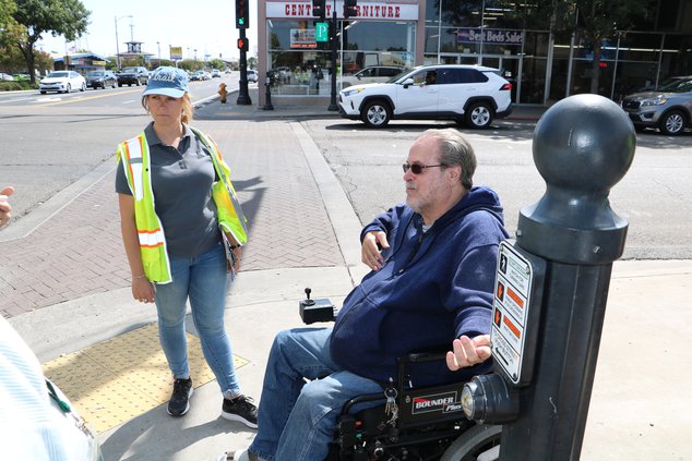
Brad Peters knows a thing or two about the challenges of getting around Manteca if you are not in a car.
Peters, who has to rely on a motorized wheelchair, was among a handful of residents attending a pair of mobile workshops Saturday — one for walking and the other for bicycling — in a bid to gather user input as part of a $300,000 study being conducted to devise a comprehensive guide to create a vision for a network of trails, bike lanes, sidewalks, and other elements to support safe walking and bicycling throughout the city as well as providing connections to nearby comminutes.
You can bend the ear of those putting together the Manteca Active Transportation Plan on Saturday, Oct. 5, from 10 a.m. to 6 p.m. at an oversized booth near Library Park during the Sunrise Kiwanis Downtown Manteca Pumpkin Fair. They will have large maps that you can mark where you want improvements made to make walking and bicycling not just safer but a more effective alternative to motorized transportation.
Saturday’s walking tour was basically a primer on the do’s and don’ts of making travel by foot safe and convenient. Missteps included tripping hazards — some obvious such as uplifted sidewalks to the not so obvious unless you are in a wheelchair or on a bicycle and have to deal with asphalt ridges and gaps where the street meets gutters — as well as bicycle racks placed in inopportune places instead of near designations. An example were racks the city had placed in the small triangle formed by Manteca, Pierce and Yosemite avenues across from interactive water play feature at Library Park.
Some of the positives such as crosswalk buttons located so those in wheelchairs can access without having to go to the edge of the curb had a few miscues. The most blatant was the push button for the pedestrian crossing on the northeast corner of Yosemite Avenue and Main Street that was awkward and somewhat of a challenge to reach from a wheelchair. Due to a curbing at the edge of the parking lot and the setback of the short pole, Peters had to lean considerably to push the button. It was a 20-inch reach when current ADA requirements say it can’t be more than a 10-inch reach.
Peters and others in wheelchairs also pointed out places on heavily traveled corridors such as the south side of Center Street after you cross the tracks as well as Rose Lane where there is no ramp to reach the sidewalk after you cross the street that also has a difficult pitch to navigate. The only way those in wheelchairs can get away from traffic at that point is a private driveway that is sometimes partially blocked by a vehicle.
While Peters would like to see improvements, he believes the city has been fairly responsive to issues when they are raised.
“The city is doing a great job as far as I’m concerned,” Peters said.
What representatives of Fehr & Peers Transportation Consultants are hoping people will share with them is identifying deficiencies that exist throughout the city whether it is in residential neighborhoods or commercial areas that residents are familiar with. It can range from inadequate lighting at night to make one feel safe walking to problematic areas to cross streets due to high speed, traffic volume or lack of sidewalks.
That can be done on Saturday during the Pumpkin Fair or you can let the city know your suggestions by accessing an online interactive map and marking it with your suggestions.
The map is accessible by going to the city’s website at www.ci.manteca.ca.us, going to “Departments” in the header and scrolling down to and clicking on “Community Development”. Then click on “Planning Department” on the left side of the page. Specific planning divisions will pop up including “Active Transportation Plan” which is where you will find the interact map.
The interactive map allows you to indicate where you would like to see the following items added: crosswalks, sidewalks, on-street bike lanes, protected or separated bikeway or bike paths, walking trails, and bicycle parking. You can also use icons to show spots that you’d like to see made safer, indicate where you believe the city needs to address upkeep issues, or add your own idea. Instructions show you how to add icons to indicate what you would like to see. It also is designed to allow you to leave comments.
Associate Planner Adam Paszkowski is in charge of the project for the City of Manteca. He can be contacted at apaszkowski@ci.manteca.ca.us or by calling 209-456-8523 for more information.
To contact Dennis Wyatt, email dwyatt@mantecabulletin.com


