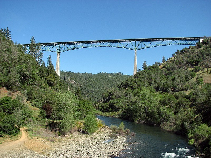
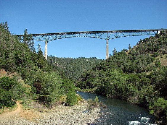
The 2,428-foot long Foresthill Bridge carrying Highway 49 across the American River Canyon some 730 feet below is California’s tallest bridge.
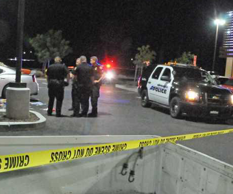
The bridge just south of Auburn earlier this week was where a 19-year-old was rescued after he trespassed to access the bridge’s underside to film a video of him swinging for social media.
The stunt went wrong and he ended up dangling some 690 feet above the river.
The bridge wouldn’t exist today if it weren’t for the eventually aborted plans to build Auburn Dam.
That’s because the dam would have flooded the existing Highway 49 river crossing where the bridge was most of the time a dozen feet above the water.
And the Auburn Dam likely would have been constructed if the proposed New Melones Dam on the Stanislaus River hadn’t irked Jerry Meral, Rob Caughlan, David Oke, and David Kay.
They didn’t like the idea the dam would devastate one of the few remaining stretches of wild river canyons in California.
The four formed Friends of the River with others, including Mark Dubois.
They gathered signatures to qualify a statewide ballot initiative to designate the Stanislaus a Wild & Scenic River under California River law.
The 1974 ballot measure failed by a narrow margin.
While they continued to try and stop the filling of the New Melones Reservoir, they began a fight to preserve the American River Canyon by trying to prevent the Auburn Dam from being built.
Mother Nature later that year gave them a helping hand when a previous undetected earthquake fault was discovered directly under the area that would serve as the foundation for the concrete arch structure designed to hold back 2.3 million acre feet of water.
Work on the dam stopped. Eventually it was “decommissioned” as a viable project in 2008 after the Friends of the River had continued to fight the idea.
Five years later, the North Fork of the American River was added to the National Wild & Scenic Rivers system.
It saved the canyon from being flooded and bringing water to a point less than 60 feet below the Foresthill Bridge.
As such, it has preserved stunning views of the canyon as you walk or drive across the bridge.
It also means the bridge — instead of ending up like the span of Highway 49 across the New Melones Reservoir on the Stanislaus River north of Sonora — has a huge drop off.
As such, it has been a magnet for stupidity since it opened in 1973.
There have been numerous clowns that thought it was a great place to bungee jump and even base jump parachuting. It has led to injuries and a few deaths.
Others have trespassed to scramble on the understructure of the cantilever bridge.
As of July, 101 people have died committing suicide. The number keeps growing despite the installation of additional fencing.
The year 1979 — that essentially sealed the fate of Auburn Dam — was also the year the fate of the Stanislaus River was sealed in the eyes of the Friends of the River.
It was when Friends of the River Executive Director Mark Dubois made a futile effort to try and stop the filling of New Melones Reservoir by chaining himself to a rock.
The message in May 1979 was clear.
The Army Corps of Engineers had two choices: They could cease filling the dam or risk killing Dubois with the entire world watching.
How rugged and remote portions of the area being flooded were is why for the better part of a week officials tried to vain to find where Dubois was chained but came up empty handed.
It worked — at least temporarily
The Army Corps stopped filling the dam and Dubois came out of hiding.
New Melones, with its 2.4 million acre foot capacity making it the fourth largest reservoir in the state, was eventually filled.
The filling of the federal dam inundated the 1925 Melones Reservoir bult by South San Joaquin Irrigation District and Oakdale Irrigation District.
That previous dam the Bureau of Reclamation had to inundate to create New Melones Reservoir along with adjudicated front-of-the-line water rights is why the two districts are entitled to the first 600,000 acre feet of runoff in the Stanislaus River basin.
The SSJID from its shared dams with OID at Beardsley, Donnells, and Tulloch provides irrigation water for an area of 72,000 acres around Manteca< Ripon, and Escalon.
The SSJID also provides surface treated water to Manteca, Lathrop, Tracy and — potentially one day, Ripon.
This little yarn is designed to make two points.
First, water issues in California tend to be interconnected from region-to -region even if you may think they are local.
That also involves a cause and effect component where a successful fight to stop a dam on the Stanislaus River can end up helping stop one 90 miles away.
It can also mean “collateral damage” such as a bridge that was never intended to leave a 730-foot drop to solid ground and a somewhat shallow river as opposed to 50 to 60 feet to standing pool of water.
The other point is what looks right on the surface to be a sound solution to water needs isn’t necessarily the case.
The seismic concern coupled with the Friends of the River effort was enough to kill what would have been the last feasible big dam project in the Sierra.
But even back when it was debated heavily in the 1960s and early 1970s before work started on a coffer dam as the first phase of construction, the Bureau was having a tough time “penciling out” the returns versus the investment to build the dam.
It was first and foremost a flood control project that would have added water deliveries, power generation and recreation benefits.
There were already three reservoirs of consequence on the American River — Folsom, Hell Hole and French Meadows.
The mid-1970s with the first “modern” drought in 1976-77 was just about when the hydrology started going back to its “normal” phase in the area we now call the western United States.
And by normal that means precipitation patterns cover the past 10,000 years or so pinpointed by carbon dating and dendrology, the study of tree rings.
That means we are in the real norm — or, if you buy into the modern take on climate change the new norm — of precipitation patterns in the area we call California.
That means less precipitation via less snow in the higher elevations. But at the same time there will be more rain in the lower elevations a.k.a. the Central Valley.
Auburn Dam — and other possible dams positioned to collect higher elevation precipitation — would not be what saves California.
It is off-stream reservoirs such as an enlarged San Luis Reservoir and the Sites Reservoir in western Colusa County that is moving forward toward groundbreaking.
Yes, the best for the future includes massive ground water recharging during the wet season by utilizing farmland.
But the dams that pool snowmelts and downpours so that the rainy season can be harvested to the max for California’s cities, farms and environment are those that we build in the lower elevation.
This column is the opinion of editor, Dennis Wyatt, and does not necessarily represent the opinions of The Bulletin or 209 Multimedia. He can be reached at dwyatt@mantecabulletin.com