Day after day, more people come to L.A.
Don’t you tell anybody, the whole place’s slipping away
Where can we go, when there’s no San Francisco?
Better get ready to tie up the boat in Idaho
Do you know the swim, you better learn quick Jim
Those who don’t know the swim, better sing the hymn
Tuna at the bowl
Find fillet of much sole!
Ooooo what can you do
With a bushel of wet gold?
— Lyrics from the 1969 song “Day After Day (It’s Slippin’ Away”
Head south out of Manteca on Airport Way and you eventually cross the San Joaquin River.
At that point you are also crossing the closest earthquake fault to Manteca — the Vernalis Fault.
It starts near Dairy Road south of Highway 132 in Stanislaus County then runs north eventually paralleling Kasson Road, passing by the Deuel Vocational Institute and Banta before ending near the Old River northeast of Tracy.
According to the United States Geological Survey this is the inferred location. That’s because while it ranks as one of the state’s 500 most active faults — California has 15,700 earthquake faults — it hasn’t warranted much attention or mapping due to its low level of seismic activity.
Active when it comes to quakes and volcanoes is a relative concept. The Long Valley Caldera — identified as one of California’s most active volcanoes as well as its largest — that is about 200 miles east of Manteca just south of a Highway 120 on the way to Benton last erupted 760,000 years ago. In comparison Mt. Lassen in the north state erupted in 1917.
Fault lines for the most part have substantially shorter time periods between significant events. The San Andreas Fault is in the high end of such a scale and the Vernalis Fault comparison in the low end. That means in Manteca, Lathrop and Ripon we will likely feel shaking from a San Andreas quake 60 miles to the west more than once in our lifetime yet never feel any movement from the Vernalis Fault during the same time frame.
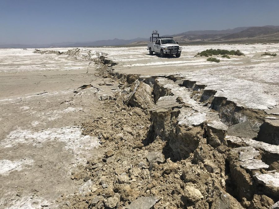
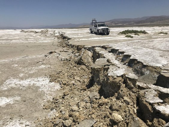
On Monday there was a 4.5 aftershock near Ridgecrest that experienced a 7.1 quake last week. It was one of 242 quakes the USGS recorded in California on Monday that were 1.5 or above on the Richter scale. The lion’s share are in the Ridgecrest area. In the last 30 days there have been 10,376 quakes in the state. California during the last 365 days based on USGS data has experienced 17,012 earthquakes. That’s 1.9 quakes every hour. There are very few that we actually feel. Most are undetected except by sensors until they approach 3.0 on the Richter scale.
There are three other known faults nearby. The Tracy-Stockton fault that runs under Stockton had significant shaking in 1881 and 1940. The epicenter of both was in Linden. The1940 event was 4.0 on the Richter scale. By comparison the 1989 Loma Prieta quake registered at 6.9 on the Richter scale.
The other nearby faults are the San Joaquin Fault that runs along the base of the Coastal Ranges from east of Newman to east of Tracy. Then there is the Corral Hollow Fault a scientist discovered in 1991. Few faults are found actually in the Great Central Valley as the forces shaping California are found in the volcanic created Sierra and tectonic plates.
California is considered one of the most diverse geological areas in the world if not the most. A dozen major tectonic plates have given us a wealth of geological variation as well as extremes. The highest point in the United States — Mt. Whitney at 14,505 feet — is just 75 miles from the lowest point of Badwater found 282 feet below sea level in Death Valley.
The geographic extremity has also given California 12 microclimates, by far the most of any state. Because of that within California’s borders you will find the world largest living thing (a Sequoia tree composed of 52,508 cubic feet), the world’s tallest living thing (a redwood tree soaring 379.9 feet) and one of the world’s oldest living things (a bristlecone pine that’s 4,145 years old). You also will find the San Joaquin Valley that grows an eighth of the nation’s food.
Last week’s Ridgecrest quake was actually centered closer to Trona.
To get an idea of how primitive some of the landscape is near Trona scenes from Star Wars were filmed nearby. Some would say Trona is a god forsaken wide spot in the road on the way to Death Valley.
That has more to do with what is taken from the soil — soda ash — than its location. Soil conditions make growing grass an exercise in futility. As a result the Trona Tornadoes’ football team that plays in an eight-man Nevada league practice and play home games on sand earning them the moniker “Sand Men” from opponents.
A place like Trona with its geological uniqueness can be found in the same state as Carmel with nearby nutrient rich Monterey Bay that supports a variety of aquatic life. The tectonic plates that keep moving against each other are the basic building block that created the state’s dozen microclimates.
All if that is why I really don’t fret much about earthquakes.
Granted I may think a bit differently if I were attending Cal Bear football games where Memorial Stadium at Berkeley was built smack dab atop the very active Hayward Fault.
Gov. Gavin Newsom last week referred to the Ridgecrest quake as a “wake up” call. While he was referring to being prepared to survive and function in the aftermath of “The Big One” everyone is worried about hitting California sometime in the near future, it is more apropos to awaken us from sleep walking through our lives as Californians.
Those 17,012 quakes during the last 365 days are helping shape not just extreme geology but extreme beauty as well. Each of those quakes along the San Andreas Fault are helping move tectonic plates between 30 millimeters and 50 millimeters a year. At that pace, Los Angeles will be adjacent to San Francisco in 20 million years.
There would be no California as we know it without quakes — or floods, wildfires, volcanoes, and glaciers for that matter.
We live on some of the most active and varied geography in earth yet we often only interconnect with it by driving through it wrapped in four tons of temperate controlled steel, aluminum, glass, and plastic-based products.
There’s whole lot of shaking going on every day in California.
We need to get out and enjoy it.
This column is the opinion of executive editor, Dennis Wyatt, and does not necessarily represent the opinion of The Bulletin or Morris Newspaper Corp. of CA. He can be contacted at dwyatt@mantecabulletin.com or 209.249.3519.