LATHROP – There is 10,887 cubic feet of water per second flowing into Don Pedro Reservoir.
And there is 10,887 cubic of water per second flowing out of it.
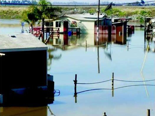
The reservoir on the Tuolumne River that travelers heading to Yosemite Valley on Highway 120 cross is at capacity. A three-day storm is expected to arrive Thursday – the last day of which is expected to raise the snow level to around 8,000 feet. That means the amount of water flowing into Don Pedro is expected to increase significantly with those releases ultimately finding their way to the San Joaquin River which is already in flood stage at Vernalis and up against the levees south of Manteca.
It’s a situation that local emergency personnel are monitoring closely as part of a coordinated effort to plan for any emergency situations that may arise.
“We’re definitely keeping an eye on that situation as it evolves,” said Lathrop-Manteca Fire Chief Gene Neely. “We’re taking the steps to be prepared for any situation that may come as a result of this storm.”
According to Neely, a coordinated effort between the fire district, the Stockton Fire Department and the San Joaquin County Sheriff’s Department has led to the activation of the Incident Management Team – a new step in emergency planning and coordination aimed at streamlining resources through a single point of command. While individual entities used to set up their own respective commands, Neely was proactive in pushing for a system similar to what is used on large wildland fires where multiple stakeholders are involved in the planning and decision making process instead of acting independently.
Aa a part of that organization, the IMT is now collecting information from local management agencies like Reclamation District 17 – which maintains the levees that will be tested if the San Joaquin River continues to rise – to formulate a contingency plan for how to safely and effectively protect those who could be adversely affected.
And that means evacuation and rescue plans.
Even though the group is compiling information and formulating necessary response plans, one of the steps involves creating evacuation plans for certain areas that may be affected – a necessary step in protecting the lives of the residents that reside within the areas that may in fact flood.
While New Melones Reservoir, which is only at 56 percent capacity, has slowed its outflow down to a trickle in order to help control the rising water on the San Joaquin River with 39 cubic feet per second flowing out and 7,202 cubic feet per second flowing in, the situation at Don Pedro may very well determine what will happen to the low-lying area south of Manteca that were ravaged by flood in 1997.
In a statement released on Friday, Modesto Irrigation and Turlock Irrigation District – the operators of Don Pedro – announced that they had no plans to open the flood gates, but that decision would be predicated on weather and the amount of water that’s flowing into the lake. Now that the outflow is matching the inflow, the lake itself is currently in no danger of rising, but that could change depending on how the incoming storm plays out.
According to some experts, there is more than 4 million acre feet of water sitting in the snowpack directly above Don Pedro – enough to fill that 2.03-million-acre foot lake more than twice.
The last time that the management agency, which includes the United States Army Corps of Engineers, opened the floodgates was in 1997. The deluge of water that was released and ultimately ended up in the San Joaquin River carved a 40-foot ravine into the land below.
But the geography of Don Pedro is significantly different than what was seen at the auxiliary spillway at Oroville Dam, meaning that a torrent of released water weakening the integrity of the structure behind it is unlikely – anchored by heavily-reinforced concrete and a much gentler slope than at California’s second-largest reservoir.
Local officials urge residents who may be residing in areas that are prone to flooding or where the possibility exists to prepare by being ready to heed any evacuation warnings if they were to be given. That means making sure that vehicles are gassed up, necessary personal effects like important documents and medications are handy, and even a small amount of cash is on hand if power is lost to some areas.
Lathrop Mayor Sonny Dhaliwal said that local officials and experts were closely monitoring the situation and remain committed to ensuring that every resident remains safe.
“We have plans in place and God forbid is something were to happen we’ll do everything humanly possible to protect our citizens.”
The City of Lathrop, which moved its offices to the west side of Interstate 5 almost a decade ago, took the step several years ago to create a duplicate computer system that would be stored at the city’s corporation yard in Louise Avenue – far from the banks of the San Joaquin River. In 1997, the decision was made to pack the freeway underpasses at Louise Avenue and Lathrop Road so that if a levee did fail, it protected the city east of the interstate. That decision was made before new homes were constructed on the west side of the freeway.
The duplicate computer system would protect the city’s vital documents in the event of a catastrophe like a flood, and will allow for its operation even if the original were to become compromised.
On Tuesday, the San Joaquin River at Vernalis formally eclipsed flood stage and is expected to fluctuate around 29 feet – with 29.5 feet considered the danger stage – through the end of Thursday. Upstream near Patterson, the river is above flood monitor stage at 49.5 feet, and won’t reach flood stage until the river hits 54.7 feet. The danger stage for that section of the river is set at 55.7 feet.
To contact reporter Jason Campbell email jcampbell@mantecabulletin.com or call 209.249.3544.
KEEPING EYE ON DON PEDRO
Lathrop Manteca Fire takes prudent steps just in case