
Flood protection isn’t the only long range impact a pending dry levee will have on southwest Manteca.
*It will effectively protect nearly 20 square miles of agricultural land from urban development.
*It will likely bolster the value of roughly 2.5 square miles of area not yet annexed to Manteca.
The reason has everything to do with what it will cost to develop land south of where the dry or cross levee that starts near the San Joaquin River and that will be extended as far east as Tinnin Rod.
“It would ultimately cost billions as billions with a ‘b’,” noted Councilman Charlie Halford who represents southwest Manteca.
Halford is referencing state-mandated levee improvements that would be required to take area to the south of the existing dry levee that will be made more robust “out” of the 200-year-floodplain.
Unlike the current $473 million effort to upgrade flood protection for 22,600 acres on the eastern side of the San Joaquin River between a point south of the Weatherbee Lake just west of Manteca to Weston Ranch in South Stockton, farther south will require major reconstruction of levees as opposed to raising and widening them.
It also would require creating another dry levee.
The weakest levee system in all of San Joaquin County is from Caswell Park to the San Joaquin River and then to Mossdale Crossing north on the San Joaquin.
There have been 11 significant levee breaks along that stretch since 1928, as well as a number of close calls. The latest major failure was in 1997 when 70 square miles between Manteca and Tracy flooded.
The current levee upgrade project will address issues in the Mossdale area.
It is there where the first flood walls in the area — concrete structures to hold back water — will be built on either side of Interstate 5’s San Joaquin River crossing due to limited area where the levee can be raised and widened.
Halford noted besides flood protection, the cross levee will allow Manteca to plan for finite development in the area.
Halford, who is the city’s representative on the San Joaquin Area Flood Control Area that is driving the $473 million in improvements, noted it will help Manteca to devise ultimate needs for everything from infrastructure and public amenities to traffic circulation for the southwest portion of the city.
There is perhaps a little more than two square miles that has yet to be developed within the city limits that would be protected by a 200-year flood levee system.
That is in addition to the roughly 2.5 square miles north of the proposed dry levee alignment that are not annexed yet to the city.
Some of that is outside the city’s current sphere of influence — areas identified for future annexation and growth.
The increased flood protection assessment on undeveloped as well as developed property is likely to set the stage for a push to include all of the area in question in Manteca’s sphere of influence when the next general plan update is undertaken, if not before then.
The passage of Senate Bill 5 in 2007 to identity 200-year flood plains in California in the aftermath of the Hurricane Katrina levee failure disaster and required protection to be in place — or work physically underway — by 2030 has essentially changed future growth dynamics for Manteca.
After 2030, areas in 200-year floodplains will not be allowed new construction to occur if it is not protected by adequate levees or else the development itself is raised out of the floodplain.
Raising it out of the floodplain would require building homes and such on raised dirt, a process that is extremely costly.
Heading east is the
‘unchecked’ frontier
Long-range growth — mostly beyond the 40-year horizon — will happen in only one general direction — east
That’s because:
*Manteca already abuts Lathrop’s city limits in the west.
*If and when Manteca reaches French Camp Road to the north, it will run up against Stockton’s sphere of influence.
Stockton’s sphere of influence already bumps up against Lathrop and runs along the train tracks including a slice on the east side of the tracks that abuts Manteca’s city limits on Roth Road across from Penske logistics (Lowe’s Home Improvement distribution center).
*In the southeast, Manteca runs up against Ripon’s sphere of influence that is as far north as Graves Road east of Highway 99.
The new 818-home Yosemite Square neighborhood on Austin Road is literally several hundred yards northwest of the Graves/Austin intersection.
That leaves the east — and northeast — as the only areas without obstacles, manmade or natural, to impede future city growth.
And given the state’s laws regarding clearly the way for more housing development making it basically next-to-impossible for cities to shutdown residential growth, Halford doesn’t see any effort to artificially restrict growth enjoying much success as Manteca heads east.
South Manteca Dry levee work
is expected to start in 2027
Work on raising and extending the dry levee just to the south of the City of Manteca is now targeted for completion by mid-2029.
The city could grow farther south to the east of Tinnin Road as it is outside the 200-year floodplain.
A 200-year flood is terminology that may mislead those not familiar with hydrology lingo.
It refers to the odds of various scales of flood events happening in any given year.
As such, a 200-year flood doesn’t happen every 200 years give or take. Instead, it has a 1 in 200 chance of happening in any given year.
The 1997 flood challenged protection that was in place — and still is — for a 100 year-flood event.
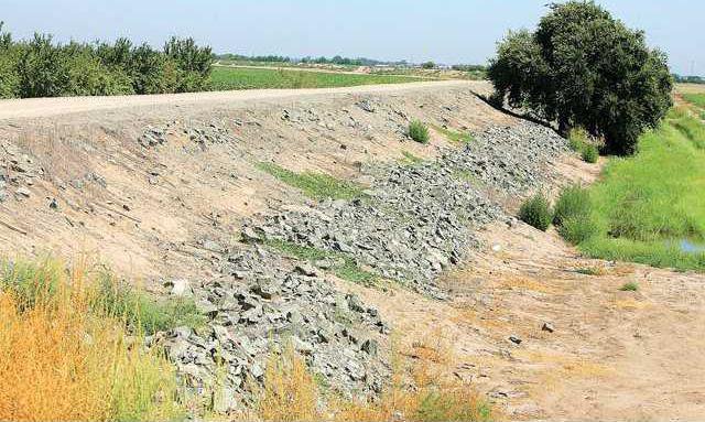
The existing dry levee will be raised by up to another two feet and widened by an additional 10 to 20 feet.
Work is expected to start in the third quarter of 2027.
It will require work on Woodward Avenue where it crosses the dry levee just south of the southern entrance to the Oakwood Shores gated community.
Hallford noted SJAFCA is working on a solution that hopefully addresses the tentative dry levee route slicing through a site for a future Manteca Unified elementary school campus effectively rendering it useless.
Several options are being explored including replacing the acreage lost with other land.
To contact Dennis Wyatt, email dwyatt@mantecabulletin.com