
Mike Barkley is not wet behind the ears when it comes to flooding in Manteca.
He knows it will return.
The Sheridan Avenue apartment complex owner who was a volunteer Lone Ranger in painting over graffiti throughout the city long before Manteca’s Seniors Helping Area Residents and Police was created, also was at the vanguard of the community-based effort to press the City of Manteca in the 1980s to address flooded streets that were virtually an annual occurrence in the central district and nearby neighborhoods.
Thirty-five years after the city started addressing flooding issues in the older sections of Manteca after being among the first valley cities to require retention storm basins tied into neighborhood parks to stop the proliferation of flooding problems brought by new development, Barkley was back before the City Council Tuesday reminding them flooding issues have not been completely resolved.
While Barkley focused on a three-story apartment project that will replace a small home on a large lot in his neighborhood it was a reminder the city has no dedicated funding for the upkeep and the eventual need to replace expensive storm system pumps as they age or the money to address increased runoff as infill projects such as the three-story apartment will cover over more ground that for years has served as a way for rain water to percolate. As more ground is covered with rooftops and pavement and even existing grass paved over in front yards for concrete driveways, the capacity of the storm drain system will be eaten up. That means the strong possibility exists that milder periods of prolonged rain could start creating flooding issues as the years go by.
Flooding in downtown
area was regular annual
occurrence until 1989
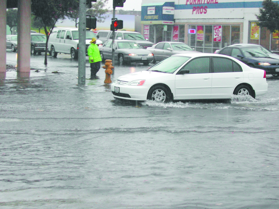
Up until the late 1980s, it was a common occurrence for downtown businesses along Center Street, Main Street, Maple Avenue as well as nearby homes to have to deploy sand bags multiple times to prevent storm water from damaging floors and furnishings.
The work done in 1989 to install larger drain pipes under Center Street and some nearby streets along with more robust intakes cut into curbs, for years eased flooding. But then as infill projects started in earnest 15 years ago, the old issues started showing signs of coming back.
The latest for downtown was 2014 when storm water flooded Center and Main with flood water lapping at businesses such as Bank of America and Don’s Mobile Glass despite storm drain intakes being clear.
The problem was too much rain in a short period that overwhelmed the system upgraded in 1989.
Some of the downtown and nearby neighborhood issues were addressed in part by a storm retention basin the city installed on Moffat as well as replacing drain pipes south of Yosemite Avenue and east of Main with larger lines.
Barkley’s neighborhood that includes his apartment complex in the 100 block of Sheridan Avenue where 88 people residents live as well as homes across the street had flooded before the 1989 improvements. That said there were scares in 2012 and 2014 during two relatively modest downpours when those properties were again threatened.
How Manteca’s
system works
How the city’s storm system works is part high-tech and part low-tech.
It starts as a light rain.
And then before you know it, the skies open up.
Rainwater runs off your roof, your driveway, your patio and other impervious surfaces.
It trickles into the gutter in a steady stream joining the run-off from nearby homes as well as the streets and sidewalks.
A running stream of water punctuated with a steady downpour flows into the storm drain and disappears beneath the streets of Manteca.
It’s below the surface in storm drains ranging from 12 inches to 48 inches or more that your rain run-off joins that from hundreds of other homes and commercial ventures.
But the trip ultimately to the San Joaquin River and into the San Francisco Bay is interrupted.
The city’s storm system is becoming overloaded. Pumps kick on and the water is taken out of the system into a nearby park that has been designed to provide double duty as a storm retention basin. It is here the water will pool with other run-off waiting for the system to clear up room so it can continue its journey.
The goal is to take pressure off trouble spots to avoid street flooding and backing water up on to private property by controlling flow with a telemetry system that has been programmed to respond automatically when workers detect problems in the city as the torrential cloud burst continues.
The water level in the storm retention basin rises providing an effective safety valve against flooding. Then capacity is freed up in the system and a second pump starts removing the water from the basin and putting it back into underground drains that make their way to the west near the Union Pacific Railroad tracks. It is here that the water comes gushing out through large screens covering culverts and into a San Joaquin Irrigation District drain.
The water will then make its way north to the French Camp Slough about eight miles away before turning west and heading past the northern levees on the northern edge of Weston Ranch in Stockton and into the San Joaquin River to continue its journey to the Bay Area and ultimately into the San Francisco Bay and beyond.
There are more than 3,000 storm drains citywide. All of the storm drains are cleaned before and after storms to prepare for the next rain. Even so it is a big help when citizens keep leaves and other debris away and off grates to the storm system.
System wouldn’t work
without SSJID canals
The system wouldn’t work without access to SSJID canals and drains that are between Manteca and the river. The city works closely with the district and shares in the cost to improvements along the drain that heads to French Camp Slough where all of the city’s storm drain water that enters pipes currently goes.
The city is dealing with a fact it can’t escape — any improvement to land increases the water run-off.
An acre of farmland that used to grow crops typical has a one-tenth of a rating for run-off.
It increases when you put grass on it, build homes, or put in streets.
It is the same reason why California’s rivers are flooding more often. There is more run-off because more land is being made impervious to percolation during heavy storms.
The city doesn’t have a separate storm system crew but instead relies primarily on sewer system workers. Whenever they work on storm system matters, their time is billed internally to that account since state law requires enterprise fund accounts that serve specific users such as those who access sanitary services can’t legally pay for service other than what the fee is collected to pay for.
Additional improvements
and deferred maintenance
Engineers have noted that it would be cost prohibitive to design and construct a system that would eliminate absolutely all prospects of flooding in the older parts of Manteca. But many of the ways to improve operation of the existing system that has been upgraded several times since the early 1990s in the central district is to make it easier for storm run-off to flow unobstructed into underground pipes.
Improvements in the past 15 years have substantially reduced flooding potential at historical trouble spots such as Moffat and Main, Center and Main and along other streets between Main Street and Powers Avenue. There can still be flooding simply because the water can’t get into the system.
The surge basin on Moffat Boulevard allows for water to be taken out of the system and stored creating more capacity for run-off. Stored water would then be released back into the system once capacity is freed up.
Manteca has unfunded
storm system needs
The City Council in 2001 dropped a $2.35 a month utility tax that was raising $690,000 a year to go toward storm system improvements and maintenance. The tax was repealed after the legality of the utility users’ tax was questioned. It was adopted on Nov. 20, 1989 as a way to fund storm drainage system improvements and maintenance to alleviate street flooding, particularly in the downtown district.
The issue of funding storm drain improvements has not been addressed in the last 18 years meaning that the storm maintenance and upgrade of the existing system is a drain on the general fund budget.
Manteca three years ago finished paying off a loan back in 1989 to make central city storm system improvements that eliminate an annual debt repayment of $223,000 a year. Ongoing maintenance since 2010 takes a $300,000 to $500,000 annual bite out of the general fund depending upon the needs. The utility tax – which would have brought in around $850,000 this year if it were still in place – would have covered that tab plus have money to go toward upgrades and replacement of aging infrastructure that staff has recommended needs to be done but hasn’t been funded. It would also free up an average of $400,000 for the general fund as storm maintenance costs would be covered. Based on current general fund spending patterns where roughly 70 cents of every dollar collected goes to public safety it would have made $280,000 available for the hiring of two additional police officers or firefighting personnel.
To address future cost issues that the city back in 2009 changed its policy of having water discharged from various park storm retention basins within 48 hours. That requires much larger pipes that add to the cost. The newer strategy calls for a water discharge rate of 96 hours from storm retention basins instead of 48 hours. That represents the longest accepted maximum time that water would sit in a retention basin before it is released into a series of underground pipes and eventually into the San Joaquin River.
Currently, it is rare for water to stand in any retention basin more than 24 hours.
In order to meet any potential future increase in the 100-year flood protection standards, the city may have to alter future retention basins to either make them deeper or larger.
The problem, however, is how to fund improvements since those serving established neighborhoods can’t legally be charged off to growth.
Federal storm
runoff requirements
Newer federal storm run-off standards that addressed water quality issues regarding urban storm water that reaches rivers as well as to reduce runoff into swollen rivers required cities such as Manteca to adopt new development standards. Roughly 85 percent of all storm water must be retained on site within a developed parcel whether it is a commercial enterprise or a part of a residential subdivision.
The need to comply with the federal National Pollution Discharge Elimination System permit administered by the Environmental Protection Agency zeros in on projects creating additional impervious surfaces — roof tops, streets, sidewalks, parking lots, and such — to reduce run-off from not just storms but landscape irrigation as well.
One likely scenario for parking lots is the elimination of continuous curbing between asphalt and landscaped areas. An example is what the city put in place on the southeast corner of Woodward Park for the parking lot near the storm retention basin. There are notches in curbing along travel lanes while raised concrete curbing has been placed with “wheel stops” to allow storm water to flow into landscape areas where it ultimately will in filtrate in to the ground.
One solution has been the more prevalent is the use of vegetated swales or small “valleys” to capture runoff from streets and large areas such as parking lots. And while many swales that exist prior to the new rules that went into effect in 2015 are planted in grass that is less likely to happen now for several reasons. They include the permit requirements frown heavily on using pesticides and any chemicals in storm run-off areas to recue pollution. The guidelines also want water use conserved at times there isn’t storm run-off.
It means such swales would most likely have trees and native shrubs.
Other measures that have been identified to help reduce runoff as well as avoiding pollution from getting into the storm retention system and ultimately into the San Joaquin River and Pacific Ocean include:
using porous pavement such as those that allow small squares of grass to grow between pavers for driveways and patios.
tree planting and preservation.
putting roofs over large waste bin enclosures, outdoor material storage areas, as well as fueling facilities.
The city also has started requiring more French drains employing river rock. Examples can be found along Moffat Boulevard at the Moffat Community Center (the Manteca Veterans Hall) and the Manteca Veterinary Clinic at Powers Avenue.
Addressing Barkley’s
flooding concerns
along North Sheridan
Barkley notes the addition of the storm retention basin to the southeast in the Curran Grove neighborhood that borders Powers and Yosemite avenues helped the situation on Sheridan.
But he’s seen that effectiveness erode as infill projects have been built. And now with a three-story apartment going just a few doors down, he expects the situation to deteriorate further.
He argues there is not enough drain capacity based on a storm in 2012 and two events in 2014 where housing along the 100 block of North Sheridan Avenue came close to flooding for the project at 649 Stewart to go forward. He believes the city needs to do two things. One is to sever the Steward Street connection with Drain 4 on his property and replace it with a storm drain line west on Stewart to connect with another line on Fremont Avenue.
Barkley also believes at the absolute minimum the pumps at Curran Grove should be turned off in advance of any storm and not turned on until the Drain 4 interceptor at Drain 5 has emptied.