
The peak water level has dropped over a foot down to 28.29 feet during the last 30 days on the San Joaquin River at the Airport Way bridge crossing.
Flood concerns, though, have heightened.
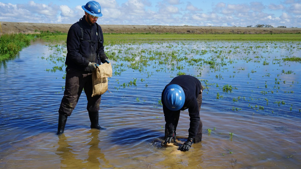
There are a number of spots where California Conservation Corps workers are sandbagging boils that keep popping up at various locations south of Manteca
In at least two spots between the Stanislaus River and the Mossdale Crossing crews are trucking in gravel, rock, and dirt to make emergency fixes to levees.
The biggest problem aren’t concerns levees being topped with water which would require the river level to be 8 feet higher that it is currently, undercutting by the continued rapid movement of high volumes of water, or becoming saturated from the pounding of numerous storms.
It’s seepage.
And nowhere is the battle more visible than along Airport Way on the Manteca side where the bridge crosses the river.
For weeks, the Manteca Sportsmen Club has been partially underwater due to seepage. It’s a common occurrence during high river levels as the sportsmen facility borders the banks where the San Joaquin River has had a notorious past for causing problems.
But what is garnering attention is across Airport Way.
Seepage was growing at a fairly alarming rate where there is a vineyard planted at the confluence of the San Joaquin and Stanislaus rivers.
For the past week or so, crews have been working with gravel, dirt, and plastic sheeting to strengthen the levee adjacent to the bridge.
Boils and why sandbags
can keep them in check
It is a repair that is critical to make sure the pressure of a rising groundwater level along the river doesn’t punch through the soil above it.
That is why when boils are spotted, the first remedy undertaken is to ring it with sand bags.
It is a bid to equalize the surface pressure with the water pressure to avoid it from going from a bubbling boil to a full blown gusher.
A sand boil occurs when the weight from the high river water pushes downward pressure on the soil layers under the levee. If the water can find a weak spot in the soil, it will seep upwards to the surface on the land side of the levee.
Sometimes it can look like it is bubbling or "boiling" and that is where it gets its name.
Sand boils can develop anytime the river level is very high, not just during heavy rain events. You typically can spot them a few feet from the base of the levee, but they can also be found hundreds of yards away too.
The water from the boil will slowly fill up the ring made from sand bags that are placed around it. In doing so, it creates some back pressure on the seepage.
Two main factors contribute to seepage:
*High water pressure within the river such as during periods when the river is near flood stage.
*Porous earth material within and underlying the levee.
Many levees were
constructed in 1850s
The levees along the San Joaquin River between the confluence with the Stanislaus River and Mossdale Crossing in Lathrop were constructed as most levees once were in California.
They were built using nearby material that often is relatively easy for water to penetrate under severe conditions. Many date back to the 1850s.
And while some levees have been upgraded or have had Band-Aids of sorts applied, there are large swaths — including segments south of Manteca — of the 13,800 miles of levees throughout California that are basically poorly constructed by today’s standards based on decades of research as well as trial and error.
Those shortcoming can be traced back to using native soil instead of importing materials that are less porous.
There is also a difference between standards for agricultural levees and urban levees in terms of widths and such.
The weaker agricultural standard exacerbates flood issues when they are forced to do double duty protecting urbanized development as growth occurs.
That is why Manteca and Lathrop — as well as at least three dozen other areas in California — are under a state mandate to upgrade levee protection by 2030 or a moratorium will be placed on new development.
Such work isn’t cheap. That explains the need for $280 million worth of levee improvements to upgrade protection for southwest Manteca, French Camp-Weston Ranch in southwest Stockton and Lathrop to the east of the river to go from 100-year flood protection to 200-year flood protection.
The 100-year and 200-year flood lingo refers to the odds of a specific magnitude of flooding that has a 1 in 100 chance and a 1 in 200 chance of happening in any given year as opposed to happening only once every 100 or 200 years.
The increased frequency of such events is contributed to urbanization that transforms dozens of square miles yearly in watersheds, such as the 15,600 square mile San Joaquin River watershed, from permeable surfaces to impermeable surfaces.
Coming snowmelt will put
Manteca-Lathrop levees to test
That includes the addition of roof tops, streets, sidewalks and such. With less ground to soak up precipitation, that means a storm of a specific size 10 year ago create significantly more run off today.
River Islands at Lathrop on the west side of the San Joaquin River has new levees that are 300 feet wide — five times wider than levees on the east side — and are in the process of being certified as being able to withstand 200-year flood event.
A more robust cross-levee south of Manteca plus enhanced river levels from Manteca to Weston Ranch will cost $280 million.
The work would effectively eliminate the concerns Manteca and Lathrop officials have with levee failures to the south.
Compounding the problem of making sure levees perform as they should is the fact there are a patchwork of reclamation districts as well as private levees across California.
The hodgepodge is considered as contributing factor — although not necessarily a major one — in the fact a levee failed on average every 7.5 months throughout the last century in California, according to the Water Education Foundation.
It is against that backdrop that a near record snowpack as of April 1 — 237 percent of average in the central Sierra and 300 percent of average in the southern Sierra — will melt this spring.
They will be flowing into reservoirs that almost all are at or beyond 100 percent of average for this time of year in terms of storage — except for New Melones on the Stanislaus River that is at 84 percent.
That means even a preferred long snowmelt without warm rain and temperatures in the higher elevation breeching 70 degrees on a sustained basis in the early part of the spring that would mean a more rapid runoff, the levees south of Manteca are expected to potentially be under stress until at least the end of May.
To contact Dennis Wyatt, email dwyatt@mantecabulletin.com