State emergency officials were bracing for the worst.
Twenty-five years ago on Monday (Jan. 3) a “boil” — so named for water that bubbles up on the wrong side of a levee meaning water is undermining it — broke on the Stanislaus River levee.
Secondary levees south of Woodward Avenue and those at the Mossdale bend on the San Joaquin River showed signs they were nearing failure.
The disaster scenario was quickly drawn up. Failure of the San Joaquin River levee where new boils seemed to be popping up every hour could send water rushing north to Weston Ranch where it would reach the first homes in that south Stockton neighborhood within seven hours.
The same break could inundate nearly a half of Lathrop.
The assessment of the potential damage from the secondary levee south of Woodward Avenue failure was somewhat better. The Office of Emergency Service envisioned a break sending water rushing toward the Highway 120 Bypass that has been designed for conversion into an emergency levee. Once there, it would pour through the McKinley Avenue undercrossing and spread out threatening the Manteca-Lathrop wastewater treatment plant, a large chunk of the Airport Way corridor and could possibly send up to two to three inches of water into the Sierra High neighborhood.
The first of almost a dozen levee failures happened 25 years ago on Jan. 5.
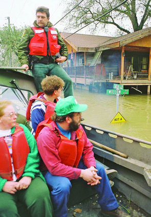
Weston Ranch residents were advised to prepare for a possible evacuation. Thousands of families did just that loading up pickup trucks, cars and rental trucks with as much of their personal belongings as possible. For several days, Weston Ranch residents were ready to flee.
The demand for rental trucks was so high Budget, Penske, Ryder, and U-Haul were unable to fill requests despite moving trucks into the area from as far away as Reno, Oregon, and Southern California.
At its peak, the flood covered 70 square miles between Manteca and Tracy, 2,000 people fled their homes, more than 700 homes and other structures were damaged, and losses were pegged at nearly $100 million.
The last floodwaters resided three months later in the Wetherbee Lake area at the western end of Woodward Avenue.
CNN reported
Manteca was
‘isolated community’
Reports on CNN made the situation seem worse than it really was. After the news network reported that on the dawn on Jan. 8 Manteca was an isolated community.
Manteca wasn’t exactly isolated as commuters inched at 5 mph down the Highway 120 Bypass, to I-5 and Interstate 205 to head toward the Bay Area.
Spreading flood water forced the evacuation of Nile Garden School where the second emergency command center been set up.
Nearly 2,000 residents fled their rural south Manteca and rural Tracy homes. Dairy farmers either created dikes to turn dairy barns into islands or else they relied on the goodness of fellow dairy farmers from as far away as Fresno who headed to Manteca with empty trailers to help move as many as 10,000 cows.
FFA students from the three high schools pitched in to using pick-ups to haul out animals and personal belongings.
Telephone circuits went dead due to an overload as darkness started to descent on Manteca-Lathrop.
Seeds for disaster
planted in November
& December in Sierra
It had all started in November and December of the previous year. Mother Nature had dumped a near-record 180 percent of normal levee of snow-fall on the San Joaquin River’s upper watershed by mid-December. The same was true on other rivers feeding into the San Joaquin including the Stanislaus. New Melones was at 95 percent of capacity since it rarely had an early run-off.
Then a series of storms dubbed “The Pacific Express” slammed Northern California on New Year’s Day dumping an inordinate amount of warm rain.
Manteca barely got wet during the storm but events to the southeast and east were set in motion as warm rain started melting snow as high as 8,000 feet that eventually set up a series of 11 down river levee failures that left some rural Manteca homes under water for nearly three months.
The first break accord on Sturgeon Bend on the Stanislaus River just south of the Airport Way bridge near the confluence of the San Joaquin River.
Crews from the California Conservation Corps were sand bagging a boil on the bend when the embankment gave way and sent chocolate-colored water racing toward the gap and setting in motion a series of events that led to one levee failure after another.
In the next six days, levees would rupture in 11 places between Caswell State Park south of Manteca and the Wetherbee Lake area southwest of Manteca.
The Jan. 5 break was followed in hours by others that sent water rising toward Deuel Vocational Institute east of Tracy and Two Rivers Road south of Manteca.
The first emergency command center was set up at the Union Road fire station about 1.5 miles south of Nile Garden School.
Wetherbee Lake’s levee failed on Jan. 7 at 2:45 a.m. putting 80 homes in the Islander Mobile Home park under 10 feet of water. More gaping holes occurred at Hays and Perrin roads. Water surrounded Nile Garden School hours after the campus was evacuated and the emergency command center moved to dry ground at the main Manteca Fire Department station on Powers Avenue.
The river-fed lake was now seven miles long.
Then came Jan. 8 when those manning the secondary levee south of Woodward Avenue and the Mossdale Bend indicated they may be losing ground.
Those levees held although OES officials say Manteca and Lathrop came perilously close to a major disaster.
The levee breaks weren’t over. On Jan. 10, a levee on Paradise Cut broke sending residents on Stewart Tract and nearby farmland fleeing. Stewart Tract is where the River Islands at Lathrop community is being developed behind super levees that are 300 feet wide designed to prevent a repeat of the 1997 disaster.
To contact Dennis Wyatt, email dwyatt@mantecabulletin.com