Manteca elected leaders are moving to provide enhanced flood protection for thousands of existing residents as well as protect critical infrastructure such as the wastewater treatment plant.
And, yes, it will also protect future growth,
Yet not all council members think the move is a good idea.
Manteca Mayor Ben Cantu was the lone dissenter on a 4-1 vote Tuesday on a measure to divert 20 percent of future city property tax receipts in the affected area to fund Manteca’s share of $280 million in levee improvements.
His rationale: Developers should upgrade the levees first before they are allowed to build.
Cantu cited the enhanced levee protection River Islands at Lathrop put in place before the first home was built that gives the planned community of 15,001 homes the new level of protection mandated by the state.
Both council members Charlie Halford and Gary Singh schooled Cantu in the reality that exists today.
They pointed out:
*Thousands of people plus improvements such as Big League Dreams, Costco, Great Wolf, and the city’s wastewater treatment plant are already imperiled in the event of a significant flood event that has a 1-in-200 chance of occurring in any given year.
*Almost all existing development in the impacted western and southwestern areas of Manteca was in place before the state changed the rules requiring 200-year flood protection instead of the previous 100-year flood protection level.
*Modeling based on development in the San Joaquin River basin creating impermeable surface areas such as rooftops, roads, parking lots, and sidewalks along with climate changes point to more frequent flooding in the coming years.
*River Islands “backdoored” its enhanced levee protection after making no progress for 10 years with state and local agencies to get a permit to upgrade the levees. They did so by taking advantage of language that allowed them to circumvent the levee approval process by essentially piling dirt parallel to the levee and then filling the space in to create a 300-foot wide barrier against flooding.
Cantu offered no alternative suggestion on how to fund the work to protect existing residents and development except to say developers should pay for it upfront.
The mayor did not elaborate or say what he would do if developers didn’t step forward in terms of improving flooding protection that would protect the lives and properties of existing residents.
He did repeatedly emphasize he believed the work should have been done years ago.
Cantu has reminded the council and public of that every chance he could in the past 3 ½ years he’s been mayor.
At one point last year he called for a moratorium on growth until better flood protection was in place.
Cantu did not raise that possibility on Tuesday.
He simply voted against what experts view is a critical funding component needed to allow levee work to proceed..
It will be combined with growth fees the city is already charging new construction in the impacted area to fund improved flood protection.
The Mossdale Tract Enhanced Infrastructure Financing also includes all of Lathrop east of the San Joaquin River, the Weston Ranch portion of Stockton, and county areas including San Joaquin Hospital, the new Veterans Administration hospital being built and the county jail and sheriff’s office.
The cities of Lathrop and Stockton along with San Joaquin County have approved similar property tax diversions for impacted areas with their jurisdictions.
Modeling based on a major 1-in-200 chance flood hitting the areas using development in place as of 2018 indicated the losses spread out over years would have an annual impact of $46 million in property damage and 1.2 deaths.
If there were a project in place, the loss on a spread-out basis would be $4 million a year and 0.7 lives lost.
Toss in projected climate change without any additional growth, a 200-year flood event in 2065 would translate into a spread-out loss of $170 million and 6.7 lives lost on an annual basis.
With a project and with additional growth and anticipated hydrology changes in 2065, the annual economic loss spread-out on an annual basis would be $37 million a year with 1.1 lives lost.
The additional levee upgrades including extending a critical dry levee south of Manteca, is excepted to be completed sometime in 2028.
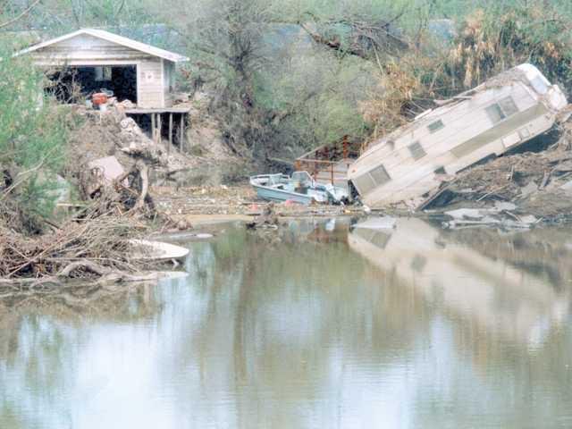
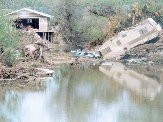
The area south of Manteca has flooded 11 times since 1929. The most flood-prone is the area nestled against the banks of both the San Joaquin and Stanislaus rivers.
Flood waters from breaks in those areas can reach Manteca hence the need for a more robust dry levee.
Should a 200-year flood occur with multiple levee failures along the Stanislaus and San Joaquin rivers south of the Interstate 5 bridge before the merger with the 120 Bypass, engineers have indicated it would among other things:
*Flood 5,000 existing homes with 3 feet or more of water.
*Endanger and force the overall evacuation of 52,000 residents in Lathrop outside of River islands, Weston Ranch in Stockton, southwest Manteca, and rural areas
*Force the evacuation of San Joaquin Hospital — the county’s major trauma center — as well as the county jail.
*Force first responders at five fire stations, and the county sheriff to abandon their stations and key communication centers in the middle of a major emergency.
*Lathrop High and Weston Ranch High would have water flowing through their campuses as would six other Manteca Unified elementary schools.
*Force the closure of portion of Interstate 5 — the major West Coast freeway running from Mexico to Canada — and the 120 Bypass.
*Water would swamp the wastewater treatment plant serving 88,500 existing Manteca residents and more than 14,000 of Lathrop’s nearly 30,000 residents.
*Disrupt Union Pacific Railroad train movements as well as damage tracks that Altamont Corridor Express relies on.
And that’s just for starters. Modeling shows a number of existing homes would likely suffer water damage in fringe areas that could receive upwards of three feet of flood water.
To contact Dennis Wyatt, email dwyatt@mantecabulletin.com