
1997 FLOOD FACTS
• FIRST BREAK: Jan. 5, 1997 at Sturgeon Bend on the Stanislaus River near the confluence with the San Joaquin River.
• TOTAL BREAKS: Eleven along the San Joaquin and Stanislaus rivers.
• HOMES DAMAGED: 800 homes & buildings
• PROPERTY DAMAGE: $100 million
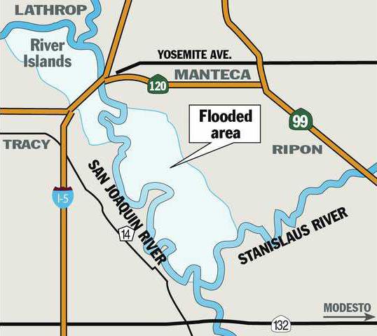
• FLOODED LAND: Upwards of 70 square miles between Manteca and Tracy
• FARM ACREAGE INUNDATED: 25,000
• DAIRY CATTLE RELOCATED: 15,000 head
• PEOPLE EVACUATED: 2,000
• OTHER TIDBITS: Weston Ranch neighborhoods were warned of the potential for mandatory evacuations
Get ready for a 200-year flood.
With California locked in the grip of a three-year drought and coming off the driest year on record, Manteca’s elected leaders are expected tonight to move forward with the first step of a state mandated requirement that they identify areas prone to 200-year flooding and take steps to protect those areas.
The Manteca City Council is considering approving spending $61,622 as its 50 percent share of retaining the firm of Peterson, Brustad, Inc. to develop a 200-year flood profile for the San Joaquin River as well as develop floodplain information for all areas protected by Reclamation District 17 levees. Lathrop’s City Council has already authorized spending $61,622 as their half of the $123,244 contract.
The study will determine how far floodwaters would spread should the levees fail plus the depth of flooding at various locations.
A lot could be riding on the study.
The state has made it clear that it will not provide emergency assistance in the event of flooding if development occurs in areas subject to 200-year flooding if adequate steps haven’t been taken to protect it.
At the same time, the information could be used to expand Federal Emergency Management Agency maps of areas that must obtain flood insurance for properties with mortgages guaranteed by federal sources such as FHA
Such policies could cost in excess of $2,000 a year per impacted household.
A major flood study in the middle of a severe drought underscores California’s never ending cycle of bust and boom when it comes to precipitation.
There have been 11 major levee breaks in areas protected by District 17 levels since 1929. The latest was in 1997
It had all started in November and December of late 1996. Mother Nature had dumped a near-record 180 percent of snow-fall on the San Joaquin River’s upper watershed by mid-December. The same was true on other rivers feeding into the San Joaquin including the Stanislaus. New Melones was at 95 percent of capacity since it rarely had an early run-off.
Then a series of storms dubbed “The Pacific Express” slammed Northern California on New Year’s Day dumping an inordinate amount of warm rain.
Manteca barely got wet during the storm but events to the southeast and east were set in motion as warm rain started melting snow as high as 8,000 feet. That eventually set up a series of 11 river levee failures that left some rural Manteca homes under water for nearly three months.
Secondary levees south of Woodward Avenue and those at the Mossdale bend on the San Joaquin River showed signs they were nearing failure.
The disaster scenario was quickly drawn up. Failure of the San Joaquin River levee where new boils seemed to be popping up every hour could send water rushing north to Weston Ranch where it would reach the first homes in that south Stockton neighborhood within seven hours.
The same break could inundate nearly a half of Lathrop.
The assessment of the potential damage from the secondary levee south of Woodward Avenue failure was somewhat better. The Office of Emergency Service envisioned a break sending water rushing toward the Highway 120 Bypass that was designed for conversion into an emergency levee. Once there, it would pour through the McKinley Avenue undercrossing and spread out threatening the Manteca-Lathrop wastewater treatment plant, a large chuck of the Airport Way corridor and could possibly send two to three inches of water into the Sierra High neighborhood.
The orders went out: Plug the McKinley Avenue undercrossing of the Highway 120 Bypass and do the same for the Louise Avenue undercrossing of Interstate 5 in Lathrop. Caltrans crews also would be ready to close the Lathrop Road undercrossing of I-5 at a moment’s notice.
If the 1997 flood had happened today and was stopped at the same locations, no homes would be flooded within either city’s boundaries. But since then neighborhoods have sprung up in Manteca south of the 120 Bypass along the Airport Way corridor as well as west of Interstate 5 in Lathrop. Both are outside of the raised freeway beds that the state planned to turn into emergency levees in 1997 of the need arose.
Also, the 1997 event was classified as a 100-year event and not a 200-year flood as mandated by the new state standards.
This time around Stewart Tract would not flood as it has in nine of the 11 previous floods. That’s because developers of River Islands at Lathrop on Stewart Tract have protected it with 300-foot wide super levees that experts say could easily withstand 200-year flood events.
The council meets at 7 p.m. at the Civic Center, 1001 W. Center St.