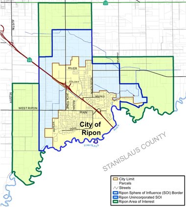
Ripon could take advantage of farmland to the west of the Jack Tone Road interchange with Highway 99 to expand its future tax base.
The City Council when they meet tonight at 6 p.m. will consider hiring Miniter Harrish for $558,290 to prepare the Westside Area Plan.
“This planning effort represents one of the most significant longe-range planning initiatives undertaken by the City in recent years,” noted Ripon Planning Director Kurt Zuidervaart.
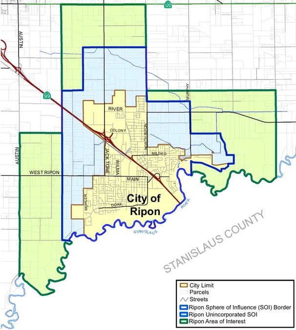
The area in question covers around 1,800 acres or just under three square miles of mostly farmland with a sprinkling of small rural estates.
It is bounded by:
*Jack Tone Road on the east.
*a point midway between Olive Ave and Frederick Avenue in the west roughly half a mile east of Austin Road as well as where the city’s sphere of influence — areas identified as a high likelihood of being annexed in the future to the city.
*roughly midway between West Ripon Road and Highway 99 to the south.
*a point a fifth of a mile north of Graves Road — between roughly 1.5 miles east of Austin Road and North Ripon Road — on the north.
The study could revive a previously pondered third interchange on Highway 99 at Olive Avenue.
That proposal surfaced 20 years ago when Stanislaus County and other agencies were interested in a second Stanislaus River crossing to open development west of Modesto.
That plan was dropped after opposition including from Ripon leaders at the time that believed it would spur premature development on Ripon’s west side.
Manteca had proposed an interchange for Highway 99 at the westward extension of Raymus Parkway that Ripon development could have piggybacked on roughly a mile south of the Austin Road interchange.
The new Austin Road interchange wasn’t on the radar when the Raymus/Highway 99 interchange was proposed.
Manteca city leaders now are looking at looping Raymus Parkway back to Austin Road to take advantage of traffic flow opportunities afforded by the new interchange that opened earlier this year.
It also avoids what was considered a $70 million to $90 million interchange given Raymus parkway connecting with Highway 99 not only would have to span the railroad tracks, but the freeway would need to be shifted to the east to make it work.
The sphere of influence adopted in 2023 but not included in the proposed study also includes roughly a square mile east of North Ripon Road, the homes along Milgeo on the south and just north of River Road on the north.
Ripon’s identified area of interest indicated the city might one day go as far west of Austin Road, against southeast Manteca’s city limits, possible birder Manteca to a point east of Austin Road north of Highway 99, and reach as far north as East Highway 120.
Zuidervaart noted the west side planning area provides Ripon with “its greatest opportunity to accommodate future growth and economic development opportunities.”
The planning effort will establish land use and infrastructure framework needed to support future development, attract private investment, expand the City’s tax base, and help future annexations.
The $558,920 endeavor is being funded from the general fund’s capital account.
To contact Dennis Wyatt, email dwyatt@mantecabulletin.com