
The big test is coming.
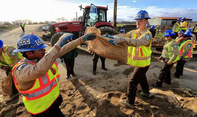
California Conservation Corps crews were feverishly working Sunday to re-enforce the most vulnerable levees south of Manteca as the first rain from a powerful Pacific Storm started pelting Northern California.
The San Joaquin River at a measuring station near Vernalis south of Manteca at the confluence of the Stanislaus River remained at “danger stage.” San Joaquin County Office of Emergency Services spokesman Tim Daly told the Associated Press that means water levels keep approaching the top of levees.
“When the water gets that high and more water is coming, there is just too much pressure and levees can break. They can be topped,” Daly said.
Daly says residents of low-lying areas have been told to be ready to evacuate, especially those in San Joaquin River Club. The private neighborhood just over the Airport Way bridge 10 miles south of Manteca has over 300 residents, many who work in Manteca.
The National Weather Service Sunday issued separate rain forecasts for the two most troublesome water basin in the state currently when it comes to flood risk — Don Pedro Reservoir on the Tuolumne River and Oroville Dam on the Feather River.
The forecast calls for 4.9 inches of rain to fall Monday and Tuesday in the watershed above Don Pedro Reservoir.
Turlock Irrigation District — which operates the reservoir Highway 120 crosses over on the way to Yosemite that has a capacity of 2,030,000 acre feet of water — Sunday issued a release describing current situations and what can occur in the coming days.
The TID indicated if the forecast precipitation develops into actual inflow into Don Pedro, the volume would put the reservoir above the 830-foot elevation. This would force TID to operate its controlled spillway in compliance with the Army Corps of Engineers Flood Control Manual for the Reservoir.
That is what happened in 1997 prior to 11 levee failures south of Manteca that led to the flooding of 70 square miles, the evacuation of 2,000 people, 800 buildings being damaged, and losses reaching $100 million.
TID stressed, “it is important to note the (today)/Tuesday combined forecast continues to fluctuate hourly in duration and magnitude. Nevertheless, prudent planning requires that TID treat these forecasts as actual precipitation numbers and operate accordingly in cooperation with multiple county offices of emergency services. TID continues to monitor storms and take necessary precautions. TID will provide updates daily.”
On Sunday the reservoir was at 97 percent capacity and was at 826.1 feet at 10 a.m. There was 9,207 cubic feet per second flowing into Don Pedro and 10,550 cubic feet flowing out.
That flow is dictated by direction from the Army Corps of Engineers to equate the river flow in Modesto at the Ninth Street Bridge in Modesto to 55.5 feet. At 10 a.m. Sunday the Tuolumne River was at 54.8 feet in Modesto.
Starting today the CHP will be closing Bonds Flat Road a J-59 and Highway 132 today at 9 a.m. in anticipation of the spillway being activated. The road closure is for an unknown amount of time.
Complicating the situation south of Manteca is the National Weather Service forecast the Manteca area may get between 1 and 2 inches of rain today and Tuesday.
That would further saturate levees that are already becoming water logged.
Emergency officials are advising non-residents to avoid the area south of Manteca where the Stanislaus River and San Joaquin River join up to avoid impeding any possible evacuation should the need arise.
Twenty years ago New Melones on the Stanislaus River was in danger of being topped forcing the Bureau of Reclamation to make significant releases. This time around New Melones is only at 58 percent of its 2.4 million acre foot capacity with 7,313 cubic feet per second flowing in and 218 cubic feet per second flowing out.
By contrast the highly televised outflow from Oroville Dam on Sunday was at 62,499 cubic feet per second.
Residents of the San Joaquin River Club have been constantly patrolling the levees for signs of danger and holding meetings to discuss evacuation routes and preparedness, said Paula Martin, who is helping coordinate evacuation plans.
“We have a levee response team, a sand bagging team, teams to check on what walkers checking on the levees find,” Martin said. “Our community is pulling together like real champs.”
To contact Dennis Wyatt, email dwyatt@mantecabulletin.com