
Twenty-four years ago today Manteca was breathing a collective sigh of relief that the flood that devastated 70 square miles along the San Joaquin River forcing 2,000 rural residents to flee left the city intact.
Emergency crews at one point had plugged the McKinley Avenue undercrossing to convert the 120 Bypass into an emergency levee. The reason was simple: The dry levee south of Woodward Avenue was touch and go for several days as to whether it would fail.
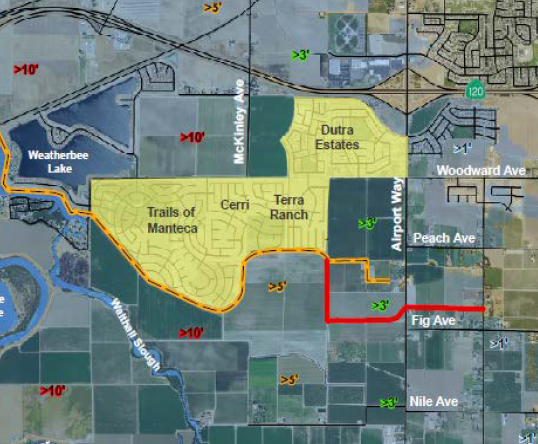
Tonight the Manteca City Council is posed to approve the final map for the first unit of 655 homes in the Cerri development south of Woodward Avenue at its intersection with McKinkey Avenue.
It is part of 3,099 single family homes approved in the 100-year floodplain long after the 1997 flood receded in most people’s memories. The other projects include the 1,237-home Manteca Trails breaking ground this year south of the gated Oakwood Shores community that is just outside the city limits.
The city along with Lathrop, Stockton, and San Joaquin County are working toward enhancing the river levees and cross levees — also known as dry levees — to withstand not a 100-year flood but a 200-year flood as now required by the state.
Homes — and other new construction in the 200-year floodplain that in Manteca includes areas west of Airport Way north of the 120 Bypass and to the west and roughly as far east as midway to Union Road south of the freeway — will pay fees toward what is expected to be a $180 million levee project.
The state mandated that physical work start by no later than 2025.
The levee upgrade authority, that includes Manteca and Lathrop, has asked for a 5-year extension until 2030. Senate Bill 5 allows for one such extension.
That means, if approved, more robust levee protection won’t be in place for 10 to 12 years from now.
Mayor Ben Cantu is the only elected official to consistently vote against approving the building of new homes in the floodplain before an upgraded levee is in place. He’ll have another chance to express his concern about what he has described as “the folly” of gambling with people’s safety and property when the City Council meets at 7 p.m. tonight during a Zoom meeting.
On the agenda is approving the final map for the first unit of the Cerri project. The council last year — following adopted polices — allowed the developer to start infrastructure improvements before the final map was adopted. Based on previous advice from legal counsel, elected officials are likely to be advised that they have no choice but to approve the map.
Cantu’s concerns are legitimate. The rating of an area as being in a “100-year floodplain” does not mean there is a likelihood of a flood on such a scale every 100 years. Instead it references the odds of it happening in any given year. That means in any given year there is a 1 in a 100 chance of the 1997 flooding event occurring.
Given when that rating was made and changes on the watershed upstream from Manteca as well as within the city, the likelihood is probably higher. That’s because every time soil is covered by streets, sidewalks, and roof tops there is more impervious surfaces. When that is combined with events such as in 1997 — an unusual mid-December snowfall in the Sierra followed by rain and then sustained above average temperatures melted the snowpack and nearly overwhelmed various reservoirs — the flooding will be worse. The heavy flow punched no less than 11 holes in the levees south of Manteca along the Stanislaus and San Joaquin rivers.
When the 1997 floods occurred, there were no homes south of the 120 Bypass threatened save for a handful of rural estates. There have been more than 1,000 homes built on both sides of Airport Way south of the 120 Bypass since then that — based on concerns expressed by state emergency officials in 1997 — could be flooded with one to three feet of water based on the 1997 event.
Southwest Manteca was
originally seen as a tech-
style business park
There was a time 20 years ago that Manteca’s leaders saw the southwest segment of the city as the Northern San Joaquin Valley “Promised Land” for a Pleasanton-style Hacienda Business Park.
It was to feature tech firms and large-scale Class “A” office operations mixed in with retail and restaurants surrounded by high density housing. A tram system was envisioned to run between what dubbed Tara Business Park and the Altamont Corridor Express station 1½ miles away.
It was what originally prompted the city toward planning to create an interchange where McKinley Avenue passes under the 120 Bypass.
When there were no takers, the next “big thing” was to create a six-lane expressway from the future McKinley Avenue interchange to serve the proposed Austin Road Business Park in southeast Manteca.
The business park concept has gone nowhere and rural residents irked about a six-lane expressway with heavy truck traffic possibly slicing up their rural lifestyle succeeded in getting the city to scale back the proposed thoroughfare although they would have preferred it had been killed off.
Today Tara Business Park has been scrapped for years and the Austin Road Business Park is dead in the water. Meanwhile both the interchange and expressway — now repackaged as a parkway with just four lanes and lots of roundabouts in lieu of traffic signals at its various intersections — are both moving forward.
And the primary purpose of both the interchange and parkway when it comes to areas south of the 120 Bypass is to accommodate more housing. More precisely, it will continue the housing development pattern that started in 1999 when the foundation was poured for the first tract home south of the 120 Bypass across from what is now Woodward Park.
There have been 3,099 more single family homes — and conceptual parcels for 502 apartments — approved so far within a mile of that interchange. There is available land south of the 120 Bypass in southwest Manteca that has yet to be subdivided for tract homes to accommodate more housing.
To contact Dennis Wyatt, email dwyatt@mantecabulletin.com