LATHROP - Some may call it a $17 million vote of confidence in the economic future of the Northern San Joaquin Valley.
Susan Dell’Osso simply calls it a smart move.
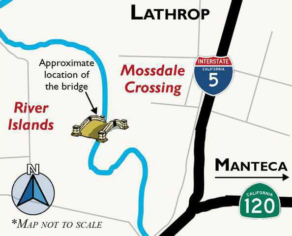
“It” is a pair of 300-foot-long bridge decks crossing the San Joaquin River from the Mossdale Crossing neighborhood into the future heart of River Islands at Lathrop. River Islands is currently working with contractors with work scheduled to start July 1.
The bridge won’t likely carry traffic for at least three years after it is built. River Islands after a decade-plus of work due to the extra-ordinary amount of regulatory hoops a planned community of 4,800 acres on the edge of the Delta had to go through on the local, state, regional, and federal levels and more than $180 million invested still isn’t ready to sell lots to builders.
They have sewer, they have water, they have flood protection and they even have put in place the Lathrop Irrigation District that will provide power to future residents and businesses 25 percent below PG&E rates. What is stopping them is the market. Or, more precisely, it is a desire to protect their investment by not diluting its value.
Dell’Osso, who serves as River Islands project manager, last year noted as new home building started picking up said the investors had made the decision to wait until the market could comfortably absorb more homes on the scale the project offers so as not to hurt their investment.
Had River Islands not been delayed in its long odyssey to gain federal approval for levee improvements, they could very easily have built hundreds of homes just as the foreclosure crisis hit. That meant River Islands – touted as a well-crafted community with an economic development component – would probably have suffered the same fate as Mossdale Crossing where at one time as many as a third of all homes were in foreclosure.
River Islands secured flood protection not from the traditional way of re-enforcing an existing levee to meet Army Corps of Engineers standards but by thinking out of the box and spending the money – $70 million-plus – to create a dry levee behind the existing levee and then filling it in with dirt. The end result is a 300-foot wide levee that is about 10 times the width of a traditional levee. The levee top will have a road plus 990 home sites.
All together River Islands will have nearly 11,000 homes as well as a town center and 320-acre business park.
The bridge work is starting just weeks before a series of tough-to-obtain permits from state and federal agencies dealing with rivers and navigable waters are set to expire.
Although the England-based Cambay Group doesn’t expect to see housing construction start until late 2013 or early 2014 at the earliest, they are going ahead out of concern that they may not be able to obtain permits again or at least re-secure them in a timely manner. They also are being motivated by significantly lower construction costs due to the current economy.
The pair of 300-foot-long bridge decks will likely stand completed for at least three years without being used. There won’t be a roadway connecting it on either side during that time nor will the dirt embankment be built up for the approach roads. It will in the interim look like a pair of giant canopies across the river. There will be a 10-foot drop-off at the bridge deck’s end until such time the approach roads are built.
The bridge, which will carry future River Islands Parkway traffic, will connect Mossdale Crossing and Old Town Lathrop to River Islands. River islands Parkway ties in to Louise Avenue.
Ultimately you will be able to take Louise Avenue where it starts east of Manteca at North Murphy Road all the way to a point west of Tracy. It effectively will be a surface bypass to Interstate 205.
The bridge to the future
River Islands bridge work starts in July