Manteca was a rarity among cities along Highway 99 as much of it was converted to freeway status in the late 1940s, 1950s, and early 1960s.
It had two fly-over ramps when the first freeway configuration popped up on what was then east of Manteca in 1955.
One was an on-ramp to northbound Highway 99 just past Northgate Drive north of Main Street.
The other was an off ramp that separated from the left lane headed northbound just past Austin Road, “flew over” the southbound lanes, and served as the start of Moffat Boulevard.
There was logic in what by today’s traffic flow and safety standards would be considered madness.
Highway 99 — known as U.S. Route 99 at its inception in 1926 and until 1972 — went from Calexico at the Mexican border where it became Federal Highway 5 to the Oregon border.
It was 754 miles.
By 1972, segments of that original alignment had been abandoned, designated as part of another highway, or replaced with Interstate 5.
In 1972, it became State Route 99 stretching 424.85 miles for Bakersfield to Redding as Interstate 5 replaced it as the main north-south trans California freeway.
Until 1955, Highway 99 went through downtown Manteca turning into present-day Moffat Boulevard.
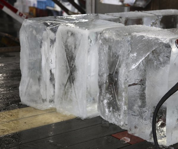
It turned right at Main Street — where for years the only traffic control was a stop sign for northbound Main Street on a corner dominated by the Union Ice Company, Diamond International Lumber, a drive-in , and New Deal Market.
It was on Moffat where one of Manteca’s first garages with two gas pumps popped up — Perry’s Garage — dating back to the 1910s in the brick buildings that today houses Anthony’s Auto Repair and Jack’s Transmissions between Grant and Lincoln avenues.
Highway 99 then crossed Yosemite Avenue that was Highway 99 until the 120 Bypass opened in the 1980s.
The Highway 99/Highway 120 crossing was where the first traffic signal appeared in Manteca courtesy of the State of California. Today, Manteca is closing in on 100 intersections controlled by traffic signals between the City of Manteca and Caltrans.
It is on the northwest corner of the intersection where the city’s most high-profile gas station sat for years — the Standard Station that is now the parking lot the City of Manteca is in the process of buying along with the IOOF Hall for $1.2 million.
Highway 99 continued north up Main Street and was close to its current alignment heading into Stockton.
Before Highway 99 became a freeway in 1955, motorists coming from the south knew they were on the outskirts of Manteca when they reached Midway Station, a service station and sandwich shop where Austin Road crossed Highway 99.
From there were the “smells” of Manteca — the Moffat Feedlot, roughly where Frito-Lay and other distribution centers are today at the back entrance to Spreckels Sugar.
That back entrance was aligned with Spreckels Road that crossed the tracks and immediately curved south past almond orchards on north side of the road until it T-intersected with Woodward Avenue following the alignment of present-day Van Ryn Avenue.
The Bypass overcrossing built in the mid-1980s cut through the orchards. The first tract homes weren’t built along the former Spreckels Road until 2002.
Moffat Bouelvard was where the first motor courts — forerunners of modern motels – in Manteca were located. There were also several service stations and a drive-in (today’s Taqueria LaCosta) and a host of warehouses.
The first tract homes along the Highway 99 corridor through Manteca were built by the late Antone Raymus in the Manga Terra neighborhood where the streets are named after a Whose Who among early American astronauts.
Highway 99 has been referenced by some as California’s Main Street.
While it heralds back to be days when it ran from Mexico to Oregon, in more recent years it was a nod to the fact it tied together more than 30 incorporated cities and even more unincorporated towns while serving as “the corridor” for the richest agricultural area on the planet — the Great Central Valley.
It also was known not too long ago by the dubious honor of being California’s most-dangerous highway with 445 deaths between 2018 and 2022 for an average of 89 per year.
That said while virtually every other city along the corridor in the San Joaquin Valley is first and foremost identified by its Highway 99 location even when there is a second highway cutting through the city, that’s not the case with Manteca.
Manteca’s main hook when it comes to freeways is the 120 Bypass.
The only other exception along the Highway 99 corridor is Stockton.
It has no less than five freeways and highways — Interstate 5, Highway 99m Highway 4, Highway 12, and Highway 88 – but is primarily seen as being an Interstate 5 city.