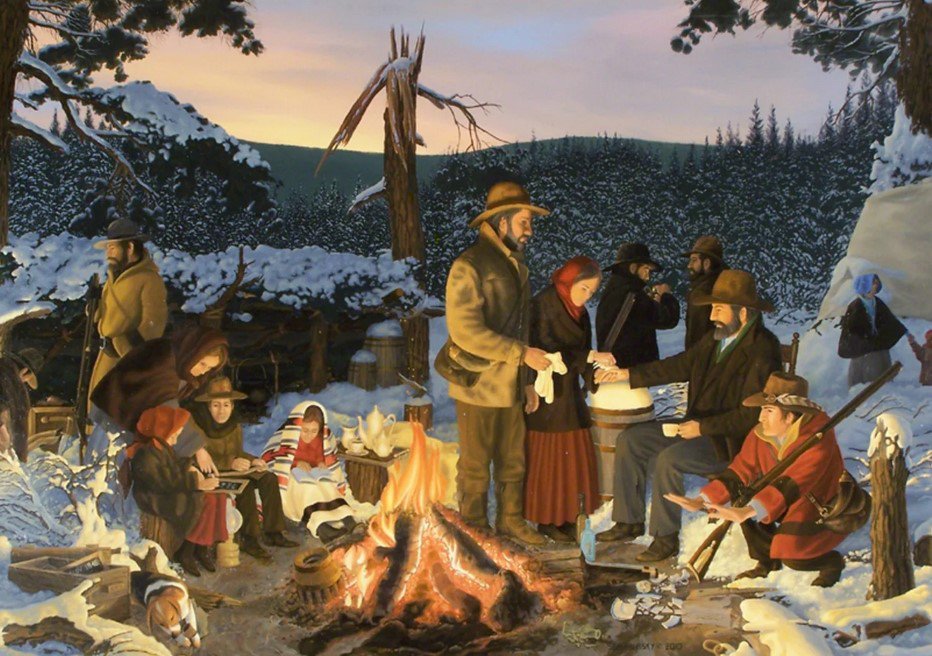

Say what want about the Donner Party but they didn’t get stranded in the middle of a Sierra winter heading to Reno to gamble or to hit the slopes at Lake Tahoe.
And while many today might think it was dumb for the wagon train to tackle the Sierra so late in 1846 queuing up events that led the name “Donner Party” to become synonymous with cannibalism, it was a brilliant move compared to what happened Monday after a heavy winter storm closed Interstate 80.
Literally hundreds of motorists put their faith in Sundar Pichai and Google Maps instead of old school agencies such as Caltrans and the CHP.
Hundreds trying to get around the freeway closure turned to their smartphones instead of common sense, to find an alternate route.
As someone who was raised in Placer County and over the course of a 10-year period made well over a hundred trips from the valley floor to the Lake Tahoe Basin, I can assure you the last roadway to close of the few that cross the Sierra would be Interstate 80.
Logic, if nothing else, would dictate that. It is where Caltrans has the bulk of its snow removal resources due to the fact it is designed as an all-weather Sierra crossing. It plays a key role in moving goods and is by far the highest trafficked pavement crossing the mountain range. When Caltrans can’t keep I-80 open during a winter storm rest assured there is likely no other alternative road open within 100 miles.
Motorists by the hundreds on Monday turned to Google Maps that told them to take other routes such as the Quincy-LaPorte Road that is gated in the winter after the first substantial snowfall and stays that way until spring. There are no snowplows assigned to it making it a popular playground for snowmobilers.
Yet the self-professed know-it-all tech company that made “google” a verb and indiscriminately siphons information from anywhere it can whether it first requires permission to do so or not, did not know a fact that all locals knew plus more than a few seasoned Sierra travelers.
Hundreds of motorists ended up getting stranded in snow. Rest assured Google didn’t advise them to take blankets, extra clothes, food, and water before taking their recommended detour. If it wasn’t for locals being on their proverbial toes, some of the people that got stuck after driving too far in the snow-covered road would still be stranded.
Motorists that take Google Maps as the gospel drove around as many as three road blocks with signage the road was closed in order to get stuck.
The award for the most reckless driver is the one that put his family in peril for taking the bait to use Dog Valley/Henness Pass Road. It’s a beautiful road for scenery — in the grip of summer. But the steep two-lane dirt road that has sections with an imposing drop on one side and a ditch that ices over easily on the other is hellish in winter. Last March even with the snowpack fading Washoe County had to rescue 25 motorists whose vehicles got stuck.
According to the Washoe County sheriff’s department, rescue efforts typically take eight hours once they are contacted but have often stretched into weeks.
So what did this driver do? He ignored lighted signs warning not to take the road and instead put his life in the hands of Google Maps.
Trusting big tech always to do the right thing, provide you with accurate information and to come to your rescue when your life is imperiled is as reckless as entrusting big government to do the same.
There is an erroneous assumption that the existence of big tech or big government eliminates all risks and allows you not to be versed in personal responsibility and self-reliance.
This week’s Sierra strand-a-thon underscores that point.
The last time a winter storm closed Interstate 80 for an extended period of time as measured in excess of a day or so, Google Maps wasn’t the dominant force it is today.
And given most people don’t carry road maps let alone topography maps when they travel through the wilderness even if it is on a four-lane freeway, rest assured most people don’t bother to check multiple sources such as sites for Caltrans, the CHP, and the down-to-the-nitty -gritty longitude and latitude National Weather Service forecast before striking out. If they can’t get key information by asking Siri or tapping an app and do so in less time than it does to download a cat video from a fiber optic connection, they move on.
On Monday the act of “moving on” could have ended badly for hundreds of people thinking Google Maps had a better handle on the situation than CHP officers and Caltrans workers braving the cold and snow to try and keep them safe couldn’t keep the easiest roadway in the Sierra open in a snowstorm.
We might think the Donner Party was in over their heads but they weren’t exactly embarked on a pleasure cruise.
They also did not even have a consistent travel-able trail to follow in most places given they got stuck three years before the Gold Rush.
The Donner Party was fortunate, however, not to have a mid-19th century version of Google Maps in their midst they could turn to in a bid to ignore wagon train masters with working knowledge of the trail in how to high-tail it out of their snow bound encampment near the eastern shore of the lake since named after them.
Had they been told to use an alternate trail to follow as opposed to the one a group took to secure the help of a search and rescue party from a settlement near Camp Far West on the Bear River, their remains may never have been found.
That trail, by the way, is a course roughly followed by surveyors and engineers that built both the transcontinental railroad and Interstate 80 given it is the easiest way to cross the Sierra.
Google might know that but unless the purveyors of such information paid the reverse spawn of Alphabet a king’s ransom on a monthly basis to have one of the rigged “highest” responses in a search the general public would be left in the dark.
This column is the opinion of editor, Dennis Wyatt, and does not necessarily represent the opinions of The Bulletin or 209 Multimedia. He can be reached at dwyatt@mantecabulletin.com