
Louise Avenue — just like Airport Way, Lathrop Road, and now Austin Road — was never conceived as city streets, let alone major arterials.
They started as narrow country roads.
That meant less muscular road base, power poles hugging the narrow right of way typical of older country roads, and homes often not even a stone’s throw away from the roadway once they were widened to four lanes..
It is why they have been problematic over the years to convert to city streets, let alone ultimately to four-lane arterials.
Louise Avenue is a prime example.
Louise Avenue was supposed to be Louisa Avenue after the wife of Noah Clapp.
The Clapps arrived in San Joaquin County in 1849 and bought land initially in Stockton where they were the neighbors of Captain Charles Weber. A short time later, they moved to what is now the Manteca area and started wheat farming.
It was originally named Louisa Avenue but when the county put the signs up it read “Louise” instead. The only family on the road for years was the Clapps.
Years later when Mrs. Clapp was asked why she didn’t have the name corrected she reportedly replied, “it’s just a little lane” and that it would never amount to much.
No one — when what is now Airport Way, Lathrop Road, and Austin Road were mapped out — ever envisioned them passing through the City of Manteca given 140 plus years ago what is today Manteca proper was a few scattered farms.
And certainly no one expected massive distribution centers such as Amazon and 5.11 Tactical along Airport Way.
Over the years as land was annexed along the corridors to the city, the maintenance of the roadways with a much lighter base to withstand traffic became Manteca’s responsibility.
Unless a development occurred with the requirement the adjoining segment of the roads be widened and repaved, the city did just the bare maintenance.
That eventually caught up with the city about 10 or so years ago, especially on the now heavily traveled Airport Way corridor.
In 2021, the council — fed up with rough pavement, potholes, and the patchwork approach to widening Airport Way — had staff devise a preliminary cost estimate to widen it from the 120 Bypass to Roth Road.
Manteca could lose $4.6M if city
don’t proceed widening segment
of Airport Way in timely manner
The cost was a staggering $130 million for four lanes with landscaped medians, and left turn pockets.
The bulk of that would occur when properties are developed with the developer footing the cost on front of their properties.
The city in 2022 spent $4 million to address sections that weren’t likely to develop in the ensuing 10 pr so years and was either on the verge of deteriorating, had rough pavement or potholes in a bid to improve drivability and safety.
The approach was to maximize what money the city could comfortably spend at the time to upgrade Airport Way that is destined to see heavier truck traffic as the years unfold.
It also was clear at the time that widening the section between Wawona Street and Airport Way would likely not be developer driven and might never happen unless the city assumed it as a municipal project.
The biggest cost item by far would be relocating or burying PG&E lines.
And is because of the need to move the lines, the effort to widen Airport Way between Yosemite Avenue and Wawona Street in 2024 became one of Manteca major road work priorities.
Manteca needs to utilize $4.6 million PG&E has set aside over the years under Rule 20 to help fund power line undergrounding projects within the city.
Rule 20 — a California Publics Utilities Commission order issued in 1967 — predates the current PG&E undergrounding effort to reduce wildfires.
The $4.6 million has been accumulated in a PG&E account over the years.
If the funds are not used soon, they can be shifted to projects in other jurisdictions within PG&E’s service territory.
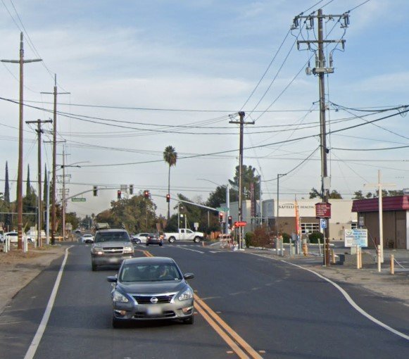
The section of Airport Way has two power lines, one on each side.
City staff noted the power poles are within in an area needed for right-of-way for what could ultimately be a four-lane street with a continuous center turn lane.
The poles either need to be set back or power lines buried underground to widen the roadway.
If the poles are set back, it would be 100 percent the responsibility of the city to provide the funding.
Undergrounding would allow the city to tap the $4.6 million.
It has not been determined if the $4.6 million would cover 100 percent of the undergrounding cost for the stretch of Airport Way.
The city staff, in 2024, was expected to start working concurrently to secure needed right-of-way with efforts to work with PG&E to commit available underground funding.
When the widening project has been discussed before, it was suggested to do it in two phases if adequate funding was not available.
That meant “three lanes” could initially be constructed — the continuous turn lane and one lane in each direction.
Needed storm drain system improvements associated with setting back power lines — or undergrounding them — would also be made in the first phase.
The second phase would include curb, gutter, and possible sidewalk as well as the second lane in each direction.
That said, nothing discussed at council level before regarding the widening per se is cast in stone.
Given the city’s recent rethinking of allowing unrestricted left turns in major arterials, the project could advance with a center median of some type.
Prior to the work on widening starting, traffic signals that just recently became operational were installed at Airport Way and Wawona Street.
They were set back to accommodate future widening just as the replacement traffic signal on the northeast corner of Yosemite and Airport was done when the dialysis center was built.
Plans calls for Airport Way to eventually be four lanes to a point north of Lathrop Road.
To contact Dennis Wyatt, email dwyatt@mantecabulletin.com