
OAKDALE – Ron Doughery knows that his new hobby of walking the exposed shallows of Woodward Reservoir isn’t going to be something that’s possible forever.
But it looks like it’ll be keeping him busy for quite a while.
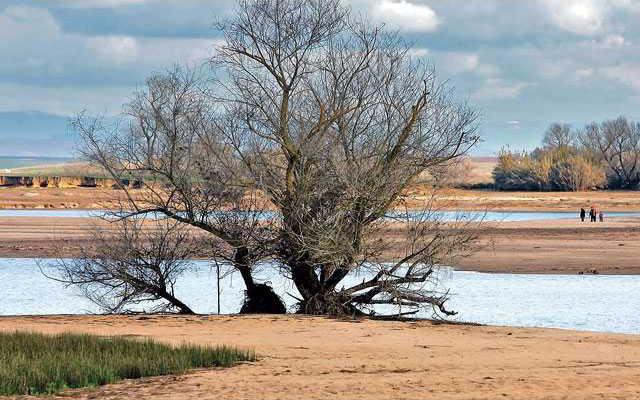
While most Californians are still figuring out how to weather the current financial crisis, the third consecutive dry winter is almost over and has left the feeding grounds for Northern California’s most precious resource – water – barren and without any sign of improving anytime soon.
South County farmers that have long benefitted by the pioneering move to dam up the Stanislaus River to generate power and store agricultural water are now facing the prospect of heading into another crippling summer worrying about whether the tap that spits out their livelihood will continue to flow.
“Looking at it now I don’t see how it’s going to fill up anytime soon unless it snows nonstop between now and summer,” Dougherty said while taking the short walk around the reservoir’s edge searching for lost items that would typically be far below the surface. “It looks like this could all dry up by July.”
On Tuesday the South San Joaquin Irrigation District – which owns Woodward Reservoir and leases it to Stanislaus County for recreational use – dedicated a portion of their first February meeting to discuss how the pending shortage will affect their ability to effectively serve their customers. The reservoir is some 16 miles northeast of Manteca and also supplies treated drinking water for Manteca, Lathrop, and Tracy as well as irrigation water for farms.
Thanks to the same soil composition that helped make the San Joaquin Valley one of the most fertile growing places in the world, SSJID officials already have to deal with seepage problems around the 100-year-old holding basin – which because of its location is considerably shallower than other reservoirs and is more susceptible to evaporation.
The reservoir, which holds 33,000 acre feet, usually loses 20,000 and 30,000 acre feet of water a year to seepage and evaporation. The SSJID plans to release 700 acre feet of water at a time from its reservoirs in the higher elevations and divert it into Woodward Reservoir. That is how much water is used for reach irrigation run.
In order to brace for the worst, the district’s board has decided to keep Woodward – which has a peak elevation of 210 feet - at 190-feet by monitoring both the influx of the melting snowpack and the outflow for both drinking and farming purposes.
In other words, it isn’t going to get much fuller than it is right now.
And the shallow season has somewhat rearranged the focal points of what is also a popular recreation destination for area residents.
With its unique location jutting away from the shore to be nearly surrounded by water, T-Island is often packed during summer weekends where families fill-up the full-access sites to enjoy quality in the great outdoors.
Today it’s empty and offers only a pristine view of the rapidly receding waters.
The boat ramp now ends five feet shy of the water. It is a good-sized hike from the camp sites to the water’s edge.
While Dougherty – who has made Woodward his home since late-fall – enjoys his daily uninterrupted walks around the lake, he also knows that the path he’s taking also means that some very uncertain times may be ahead.
“I had heard that they were predicting that it’s supposed to be a dry time for us – not a lot of rain,” he said while clutching a freshly discovered gold earring. “If that’s true I hope this is the end of it because it doesn’t look like this can go on forever.”
But it looks like it’ll be keeping him busy for quite a while.
While most Californians are still figuring out how to weather the current financial crisis, the third consecutive dry winter is almost over and has left the feeding grounds for Northern California’s most precious resource – water – barren and without any sign of improving anytime soon.
South County farmers that have long benefitted by the pioneering move to dam up the Stanislaus River to generate power and store agricultural water are now facing the prospect of heading into another crippling summer worrying about whether the tap that spits out their livelihood will continue to flow.
“Looking at it now I don’t see how it’s going to fill up anytime soon unless it snows nonstop between now and summer,” Dougherty said while taking the short walk around the reservoir’s edge searching for lost items that would typically be far below the surface. “It looks like this could all dry up by July.”
On Tuesday the South San Joaquin Irrigation District – which owns Woodward Reservoir and leases it to Stanislaus County for recreational use – dedicated a portion of their first February meeting to discuss how the pending shortage will affect their ability to effectively serve their customers. The reservoir is some 16 miles northeast of Manteca and also supplies treated drinking water for Manteca, Lathrop, and Tracy as well as irrigation water for farms.
Thanks to the same soil composition that helped make the San Joaquin Valley one of the most fertile growing places in the world, SSJID officials already have to deal with seepage problems around the 100-year-old holding basin – which because of its location is considerably shallower than other reservoirs and is more susceptible to evaporation.
The reservoir, which holds 33,000 acre feet, usually loses 20,000 and 30,000 acre feet of water a year to seepage and evaporation. The SSJID plans to release 700 acre feet of water at a time from its reservoirs in the higher elevations and divert it into Woodward Reservoir. That is how much water is used for reach irrigation run.
In order to brace for the worst, the district’s board has decided to keep Woodward – which has a peak elevation of 210 feet - at 190-feet by monitoring both the influx of the melting snowpack and the outflow for both drinking and farming purposes.
In other words, it isn’t going to get much fuller than it is right now.
And the shallow season has somewhat rearranged the focal points of what is also a popular recreation destination for area residents.
With its unique location jutting away from the shore to be nearly surrounded by water, T-Island is often packed during summer weekends where families fill-up the full-access sites to enjoy quality in the great outdoors.
Today it’s empty and offers only a pristine view of the rapidly receding waters.
The boat ramp now ends five feet shy of the water. It is a good-sized hike from the camp sites to the water’s edge.
While Dougherty – who has made Woodward his home since late-fall – enjoys his daily uninterrupted walks around the lake, he also knows that the path he’s taking also means that some very uncertain times may be ahead.
“I had heard that they were predicting that it’s supposed to be a dry time for us – not a lot of rain,” he said while clutching a freshly discovered gold earring. “If that’s true I hope this is the end of it because it doesn’t look like this can go on forever.”
