Living outside of Manteca’s city limits means you might actually have a bigger personal stake in what the City Council ultimately adopts as policy goals in the next general plan designed to serve as a blueprint for municipal growth.
Just ask residents in rural South Manteca that live along Peach Avenue, Fig Avenue, Tinnin Road, and Oleander Avenue among other country roads.
Since before 2011, the future of their homes and farms have rested to a great deal with city efforts to execute the current general plan adopted in 2000. That’s because they are part of an adopted sphere of influence — modified in concert with the general plan — that identifies areas where the city ultimately could grow. Once spheres are put in place, it sets in motion long range goals such as ultimate traffic circulation plans adopted as part of the general plan document.
The dagger pointed at rural South Manteca is the alignment of Raymus Expressway.
Their battle — plus the city gearing up for an adoption process for an updated general plan to go in place by 2020 — should be a wake-up call for rural residents north of Manteca to French Camp Road as well as to the east along Austin Road and beyond.
Manteca plan for
future growth
encroaches on
Delicato winery
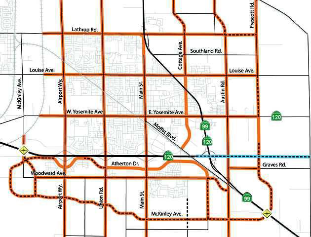
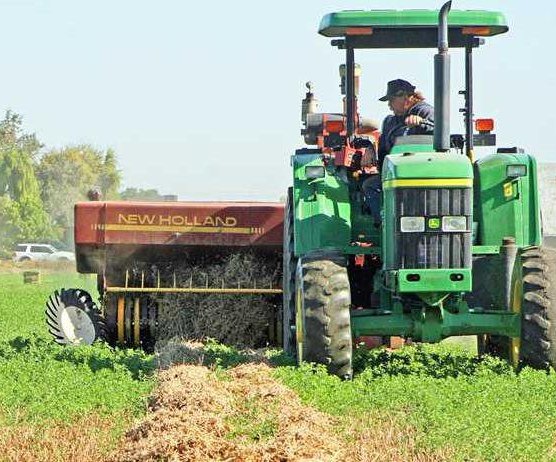
That’s because the traffic circulation plan in place calls for no less than seven major road extensions that would substantially change the rural character along Castle Road, Prescott Road, and North Union Road as well as encroach on one of the nation’s largest wineries and one of Manteca’s largest private sector employers — Delicato Vineyards. That plan also calls for a new interchange along Highway 99 midway between French Camp Road and Lathrop Road.
By not being aggressively involved in the 2000 general plan adoption, rural south Manteca residents missed an opportunity to possibly short circuit the push for what was then known as the McKinley Expressway. It was introduced in part by a proposal to develop the envisioned Tara Business Park similar Hacienda Business Park in Pleasanton where Oracle and Kaiser have employment centers.
Tara Business Park, which had been proposed south of where the city is proceeding with preliminary work to construct an interchange at McKinley Avenue and the 120 Bypass, has since been dropped. About nine years ago the Austin Road Business Park surfaced prompting traffic consultants and city planners to rethink McKinley Avenue (now referred to as Raymus Expressway) as a truck route to serve the project.
That project has since fallen apart as well although the 1,049 acres were annexed and zoning put in place for business park, commercial, and residential uses. A residential project connected with part of the 1,049 acres is now moving through the city planning process.
Rural south Manteca residents were told by city staff in 2011 during a workshop conducted at the Manteca Library McFall Room on the traffic element that McKinley’s exact alignment wasn’t a pressing issue as it would be 30 to 40 years before anything was likely to happen.
Five years later the need to plot the alignment of an extended and buffed up cross levee south of Woodward Avenue to meet the 200-year floodplain protections mandated by the state via Senate Bill 5 has made the alignment of the Raymus Expressway a pressing issue.
While it isn’t common, the general plan process has been used in some cities to shrink the sphere of influence. Once an area outside the city limits is taken out of the sphere of influence, the city would not be planning for future growth in the area including major road alignments.
Whether it is feasible for Manteca to go north — especially east of Highway 99 between French Camp Road and Lathrop Road — has never been debated.
Consultants essentially deemed it probable by the fact it was along the Highway 99 corridor and it seemed logical on a map. Manteca’s sphere of influence to the north abuts Stockton’s sphere along French Camp Road.
Some developers such as Mike Atherton have noted over the years the area is already divided into too many small parcels to make it easy or even possible for it to be developed given significant investments would be needed for water, sewer and storm lines as well as major streets. The only way that obstacle could be overcome is for all property owners either to have s consensus and help fund such improvements that could easily cost tens of millions for the area or else for almost every small parcel owner to sell out to a developer.
General plan calls for
long list of major road
extensions and widenings
Here’s what the existing City of Manteca general plan traffic circulation element calls for north and east of the existing city limits:
extending Lovelace Road from Union Road to Austin Road with an interchange at Highway 99.
extending Roth Road from Airport Way to Union Road.
extending Cottage Avenue north of French Camp Road following the Castle Road alignment.
extending Lathrop Road to Prescott Road.
realigning Austin Road north of Lathrop Road so it runs east of New Haven School and rejoins its current alignment at Northland Road.
extending Prescott Road south to the proposed Raymus Expressway interchange on Highway 99 midway between Ripon and Manteca.
widening French Camp Road to four lanes from Union Road to Castle Road.
Other major road projects identified in the current general plan’s traffic circulation element includes:
uwidening Airport Way to six lanes between Daniels Street and Atherton Drive and four lanes from Daniels Street to Roth Road.
extending Atherton Drive from Union Road to McKinley Avenue.
extending Atherton Drive as four lanes south of Woodward Avenue to the future Raymus Expressway.
widening Yosemite Avenue to six lanes from Highway 99 to Austin Road.
widening Highway 120 east of Austin Road to four lanes.
widening Union Road from Del Webb at Woodbridge to Lovelace Road to four lanes.
widening Roth Road to four lanes from Airport Way to the railroad tracks.
widening Lathrop Road from Highway 99 to the railroad tracks to four lanes.
widening Louise Avenue from Airport Way to the railroad tracks to four lanes.
extending Daniels Street from Costco to McKinley Avenue as four lanes.
widening Woodward Avenue east of Bridewell Avenue to Atherton Drive to four lanes and then swinging it to the southeast to intersect with Austin Road.
widening Austin Road to four lanes from East Highway 120 to a point a half mile north of Graves Road.
widening Louise Avenue to four lanes from Main Street to across Highway 99.
widening Union Road to six lanes from Daniels Street to Atherton Drive.
widening Main Street to six lanes from Industrial Park Drive to Atherton Drive and four lanes to Tannehill Drive.
To contact Dennis Wyatt, email dwyatt@mantecabulletin.com
MANTECA HEADING NORTH?
Major road plan clashes with rural living