Things are indeed greener on River Islands at Lathrop.
Even with the drought deepening things are staying green and alive in the planned community of 11,000 homes thanks to arguably the “greenest” water system in the Northern San Joaquin Valley if not all of California.
Not a drop of potable water is being used to irrigate 70,000 plus trees and shrubs already in place in common areas as well as front yards and park grassland.
River Islands is the first valley community to make it possible to eschew using potable drinking water to irrigate landscaping thanks to tapping into the high water table, river water, and recycled wastewater.
And as an end result, the engineered water system means will use a third of the water that was pumped from the San Joaquin River when the 4,800 acre Stewart Tract was entirely farmed. Typically in California urbanization of an acre of farmland sees no net change in water consumption.
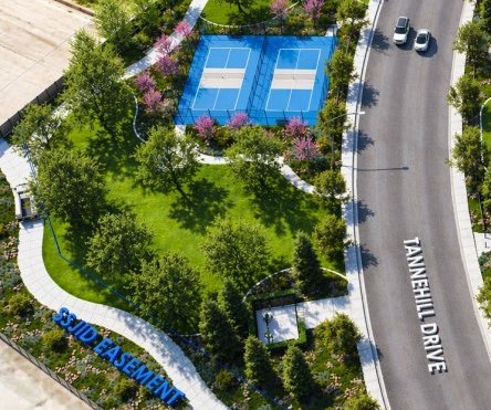
It also helps that expansive front yards as well as big back yards won’t be found at River Islands such as those that continue to pop up in new Manteca developments. River Islands makes up for that with walkable corridors, more parks, and what will arguably be the biggest city “park” ever conceived in San Joaquin County — the 300-foot wide, 18-mile linear park that encircles the community atop super levees.
The planned community’s ability to drastically reduce per capita water use was made possible by Cambay Group’s holistic approach not just to development but to water.
Based on floodplain projects elsewhere where developers fight water, Cambay Group opted to work with water to maximize its effective use and minimalize its destructive tendencies.
River Islands already has 1,900 homes occupied and another 500 sold.
It is being developed on the southeastern of nearly 60 land tracts reclaimed from the vast San Joaquin-Sacramento Delta marshland created by nature.
The first levee was put in place by pioneers in 1850 to allow farming the rich soil. The last levee that helped create more than 700 miles of winding waterways — of which 18 miles surround River Islands — was finished in 1930.
Back in the 1990s before homes were built to the west of the pre-existing levee carrying Union Pacific trains, it wasn’t usual in June during high river flows for high ground water to create mushy ground in spots limiting crop options.
And because Stewart Tract — the official government name for the 4,800 acres that River Islands is being built on — is located at a chokepoint where the San Joaquin River first enters the Delta, it has flooded numerous times in the past.
Water — whether there is too much of it flowing down rivers, not enough of it, heavy storm run-off, for sustaining ecological systems, or its quality — is the basic building block of civilization. But unlike most other developments, River Islands’ size and its location required a fully integrated solution with nature while at the same time reducing water consumption.
The planned community of 11,000 homes as well as a business park that is expected to be anchored by the first transit village in the San Joaquin Valley once the link to the BART system between Lathrop and Dublin is in place has managed to address water issues arguably more successful than any other development in California.
River Islands features:
*A system of siphons and pipes that ultimately will connect more than a dozen manmade lakes rely on water hydraulics means water levels during storms, high river flows, and times of drought can be controlled by a single pump house contained in a building that looks like a home. In doing so it minimizes the need for energy.
*The 300-foot wide super levees provide River Islands unparalleled flood protection and are certified to withstand at least a 200-year flooding event. The bottom width of River Islands levees are close to three times wider than others found in the Delta.
*The lakes now in place and those that we be created in future phases provided 100 percent of the material needed to fashion the levees.
*Homes as well as front yards and park grasslands are irrigated through the use of moisture sensors assuring water is not bring wasted.
Each manmade lake was carefully designed to assure water quality, flood and storm run-off control, and even safety.
Swimming is not allowed in any of the lakes. Even so, as a safety measure they are all designed with shelves that go out 20 feet from the water’s edge with a gentle slope that starts at 2 feet in depth.
The high water table and the sandy soil has helped lower the natural high water table somewhat giving that water a place to go. At the same time extensive river rocks lining the sides of the lakes helps naturally filter storm runoff. The manmade lakes are the storm run-off system.
The point where the water from the high water table is removed from the lake system to flow through the irrigation pipes has a series of boxes that assures when reclaimed wastewater is needed to supplement the non-potable water from the high water it is mixed without worry of it flowing into the lake system.
And while the State Water Quality Control Board has no qualms with the quality of the recycled water, it is an example of the redundancy River Island has built into its various water systems.
To contact Dennis Wyatt, email dwyatt@mantecabulletin.com